Worldwide Zip Code Database
Updated Weekly
A complete offer of location datasets ready for Enterprise and Product Integration


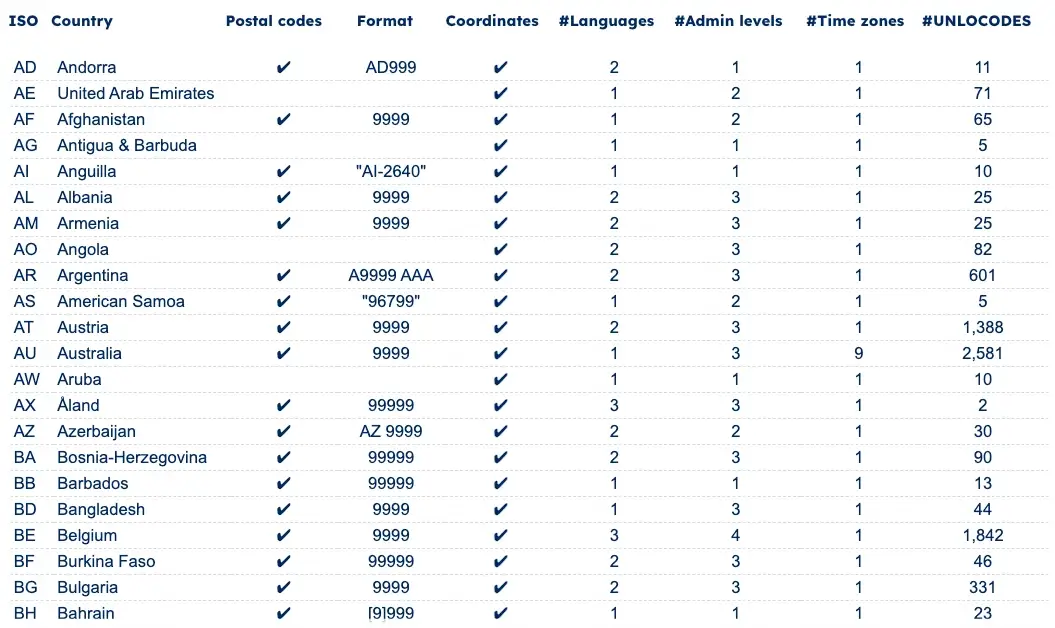
Global coverage of 247 countries
SOLUTIONS
Get the right data for your use case
Address Capture and Validation
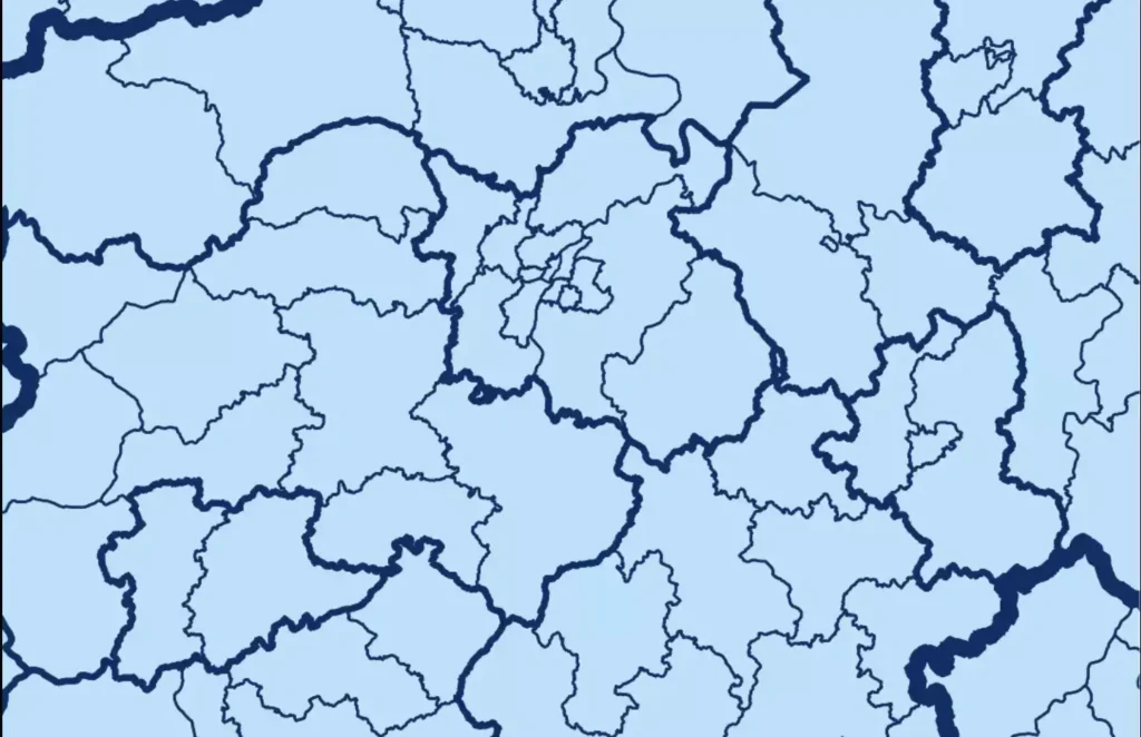
Map and Visualization
Reporting and Business Intelligence
Master Data Management
Rely on a single source of truth to scale the quality of your location data. Ensure accuracy, consistency, and timeliness across your systems and organization.
Logistics and Supply Chain
Design and optimize your distribution network, plan your pick-up and drop-off locations, reduce costs and improve visibility over your shipping.
Market Research and Geomarketing
Segment your respondents and customers, design sales areas for site selection, retail analytics, and targeted campaigns.
Custom Package
We help you build a solution for your use-case.
Master Data Management
Logistics and Supply Chain
Sales and Marketing
Custom Package

GeoPostcodes has been our go-to partner for our worldwide geodata needs since 2020. Their database is the most comprehensive we've encountered and its quality is unmatched.
Nick Beaugié
Software Engineer


“GeoPostcodes' customer success is top-notch. Angela has helped us a lot through our integration process, and she has been quick to answer all our inquiries. She also makes sure we get the most value out of their postal data.”
Antoine Pairet
CTO and Co-founder

Our data in numbers
All location data you need are available in our datasets
Fully and accurately geocoded
Fully and accurately geocoded
Multi-language support
Multi-language support
Fully and accurately geocoded
Fully and accurately geocoded
Comprehensive city definitions
Comprehensive city definitions
UNLOCODE and IATA codes
UNLOCODE and IATA codes
Administrative areas
Administrative areas
International Address Formats
International Address Formats
UNLOCODE and IATA codes
A complete and clean list of geocoded Logistics’ locations, associated with the closest zip codes (postcodes in UK) and cities.Administrative areas
The subdivisions of each country are prioritized in up to 4 levels. Our enterprise-built connector will help you adapt our standardized structure to your system of choice.International Address Formats
Indicates, per country, which fields should appear on addresses and where, in line with the requirements of each postal operator.Time zones and DST
A complete list of time zones, future on and off dates of Daylight Saving Time changes for all the time zones in the world, for each zip code (postcode in UK) and city.Time zones and DST
Time zones and DST
WHY GEOPOSTCODES
Use our data to increase quality, reduce costs
and free up internal resources
Enterprise Grade Service
- 100+ successful integrations
- 100% GDPR compliant
- On-premise data
Plug and Play Design
- Standardized and unified data structure
- Reduce integration time by 30%
- 299 languages
Highest quality
- Weekly updates
- 247 countries
- Fully geocoded
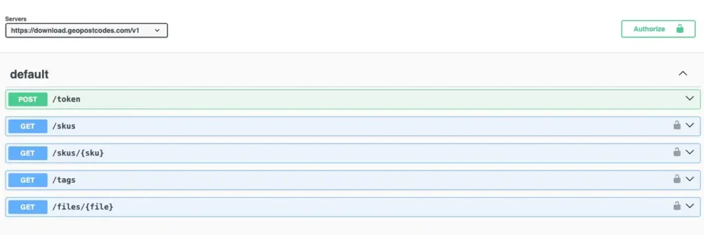
DEVELOPERS DOCUMENTATION
Our standard data format
On-premise
Our data can be downloaded and easily imported into any software, database, MDM, CRM, ERP, or GIS system.
Get automatic differential updates and a list of historical ID changes by using our download API.
Flexible data formats include

Normalized
The Normalized tables provide unique and interrelated lists of the different entities in the dataset: countries, administrative levels, places/localities, and postal codes.
Links between tables are made through record IDs, and constraints (e.g., uniqueness, foreign keys, etc.) ensure the integrity of the data.
Denormalized
The easiest format to integrate into your systems. All data are combined into one comprehensive table for immediate access.
Check our related articles


Frequently Asked Questions
The GeoPostcodes’ Postal database covers the whole world with a standard structure. It includes data from all other countries than USA, which USPS covers. USPS does not deliver an exhaustive database of addresses nor postal codes in the USA, but only tools to verify postal codes or addresses.
Other vendors collect USPS information and resell it. The GeoPostcodes Postal database differs from that USA data by all the features and services detailed above, for instance, the multi-lingual support, the geocodes and the timezone information.
A ZIP Code is a numerical system consisting of 5 digits utilized by the United States Postal Service (USPS) to facilitate the sorting and delivery of letters to their intended destinations. The term “ZIP” stands for “Zone Improvement Plan.”
In other countries, the terms “postal code”, “postcode” or “pin code” are also used. ZIP code data plays a crucial role in various business operations within the United States, serving as a vital parameter for mailing, fraud detection, and demographic research tasks.
The size of a ZIP code database can vary depending on the level of detail and the amount of information it contains. A 5-digit ZIP codes database and their corresponding city or location names would typically be relatively small in size, usually measured in kilobytes (KB) or megabytes (MB).
However, more comprehensive ZIP code databases can include additional data such as coordinates, county names, state codes, and other geographical attributes. These databases can grow significantly in size, ranging from several megabytes to gigabytes, depending on the extent of information they provide.
A billing ZIP code is a numerical code to identify the location of the address associated with a credit or debit card. When making a purchase or transaction online or in person, merchants often require customers to provide their billing ZIP code as a security measure to verify the authenticity of the card.
By matching the provided billing ZIP code with the one associated with the card on file, merchants can reduce the risk of fraudulent transactions.
As of today, there are more than 40,000 ZIP codes in the United States. Please note that ZIP codes can be added, modified, or removed over time due to population changes, urban development, and other factors.
While “postal code” and “ZIP code” generally refer to the same concept in the United States, be aware that the terminology and format may differ in other countries. The term “postcode” is common in the United Kingdom, Australia, the Netherlands, and Germany, while “postal code” is generally used in the rest of the world, such as in Asia. In India, the most common term used is “pin code”.
The five-digit ZIP code represents delivery points throughout the United States (incl. PO boxes) and is composed of three main parts: the National Area, Region or City, and Delivery Area. Additionally, USPS has divided the entire country into 10 ZIP Code areas, numbered 0-9, starting from the northeast. The first digit of the ZIP code indicates the state to which the mailer should be sent.
A ZIP Code is a postal code used by the USPS to identify specific mail delivery areas.
It denotes precise geographic locations for mail sorting and delivery. ZIP Code Tabulation Areas (ZCTA) are statistical entities created by the Census Bureau (American Community Survey) based on aggregating census blocks sharing the same predominant ZIP Code. It’s used for census data reporting and demographic analysis.
In essence, a ZIP Code refers to a postal area for mail delivery, while a ZCTA is a statistical approximation of that area used for census and data analysis purposes.
For the past 15 years, we’ve mapped the world ZIP codes, saving you the effort. Over the years, we’ve gathered valuable knowledge, enabling us to create the most complete and accurate ZIP codes database files in the world. We use 1,500 different data sources and update our database 3 times a week.
Our databases are available through an annual license. This license covers the full right to use our data. It also includes full access to product updates and support. Our Enterprise and Product Licenses also come with several days of integration help included.
The cost of our database depends on the geographical coverage your use case requires. Additional datasets can also be included.
To receive additional information and an offer tailored to your needs, please contact us via our request quote page.
Weekly updates
Our advanced version of data pipelines capture, clean, format and integrate over 1500 worldwide data sources on a daily basis, allowing us to deliver the most up-to-date global picture to our customers at any time. Subscribe to our continuous updates and stay in sync with postal and administrative changes around the globe. Our long-standing partnerships with national and international post office operators guarantee the timely delivery of accurate information. Some of our use cases for businesses include address validation, master data management, zip code distance calculation, latitude/longitude converter, radius search, city granularity counties by zip code.