
When your business operates internationally or communicates with partners in the United States, understanding the intricacies of American postal codes becomes essential. As we know in the UK, our postcode system uses an alphanumeric format that can pinpoint locations down to specific buildings. The US employs a different approach with their ZIP code system, and the ZIP+4 extension offers a comparable level of precision.
This article explores ZIP+4 codes in the USA and similar “micro-postcodes” worldwide, including Ireland, here in the UK, the Netherlands, Canada, and Brazil. We will also explain when these micro-postcodes are necessary, when standard postal codes are sufficient, and how to find a full ZIP code.
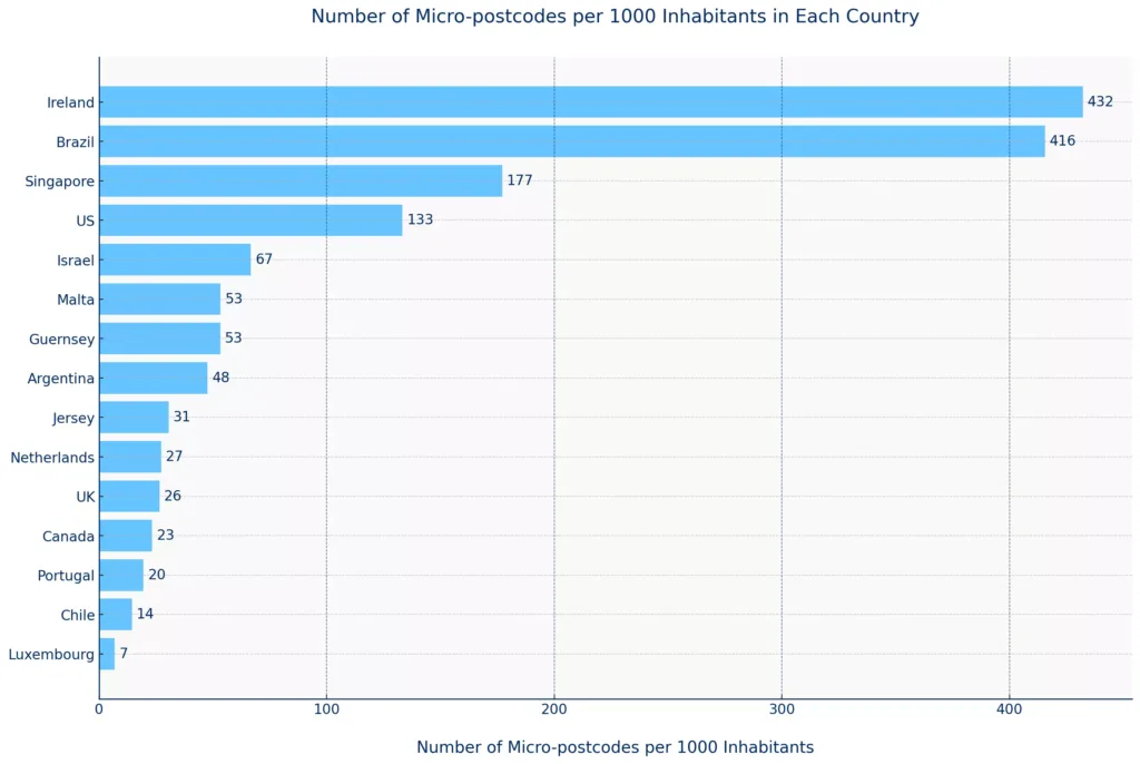
Other nations have micro-postcode systems, like full ZIP codes, in addition to the ones mentioned. For example, Singapore, Israel, Malta and Argentina use these codes as well. Check out the chart below for more countries that employ micro-postcode systems.
Discover the Map Explorer
Navigate, search, and explore detailed postal geographies using our U.S data.
What are ZIP+4 Codes?
The ZIP+4 code system, also known as the “plus-four code,” extended code, or full ZIP code, adds four additional digits to the standard five-digit ZIP code. The purpose is to narrow down a location within a delivery ZIP code area, possibly to a specific building, floor, or apartment suite—much like how the inward code in our UK postcodes identifies particular streets or properties.
Why use ZIP+4 or a Full Postcode?
For locations with multiple delivery points within a single ZIP code, such as large office buildings, universities, or apartment complexes, ZIP+4 codes help ensure mail reaches the correct recipient.
This level of detail is essential in environments where multiple individuals or departments share the same basic address, as it significantly reduces the chances of mail being misdelivered. We see similar challenges in the UK with large business parks or residential developments where precise postcode details make all the difference. For instance, a university in the United States might use a full ZIP code to ensure that admissions documents reach the correct department immediately—much like how UK universities rely on specific postcode details to manage their extensive internal mail systems.
Do Businesses Need ZIP+4 Codes?
In business operations, standard ZIP codes are generally sufficient for validating addresses, market analysis, logistics optimisation, and enhancing user experiences.
Many businesses find that standard ZIP codes meet their needs because they provide the necessary geographic information without the added complexity of ZIP+4 codes. The additional detail offered by ZIP+4 or a full ZIP code is often unnecessary for routine mailing tasks, making standard ZIP codes more convenient and easier for everyday business operations.
This mirrors the experience in the UK, where while full postcodes are ideal, sometimes broader postcode areas suffice for certain business intelligence or market segmentation activities.
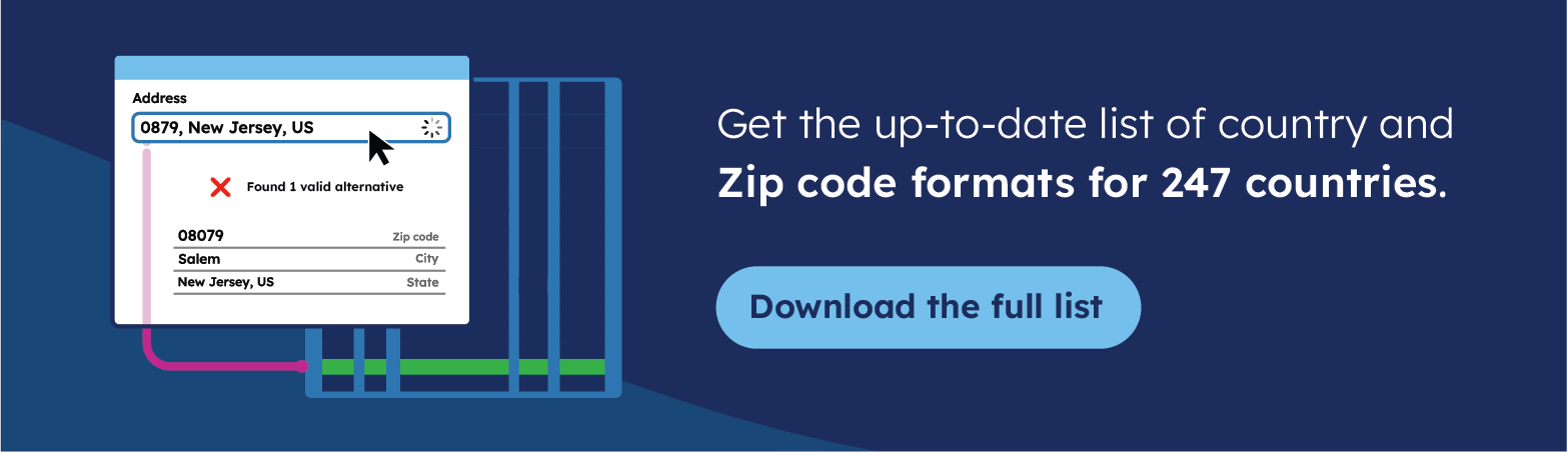
💡 For over 15 years, we have created the most comprehensive global postcode database, sourced from 1,500+ authoritative providers and always up-to-date. Browse GeoPostcodes datasets and download a free sample here.
Breaking Down the ZIP+4 Structure
To understand the structure of the ZIP+4 code, let’s examine the full ZIP Code of a prominent American address, the White House: 20500-0004. As someone familiar with the UK’s structured postcode system, you’ll appreciate how the American system also employs a logical hierarchy:
The First Five Digits (20500):
- Indicate the region, Sectional Center Facility (S.C.F.), and post office or delivery area
- Similar to how the UK outward code identifies the postal district
The Sixth and Seventh Digits (00):
- Specify a smaller area, like a city block or large building
- Comparable to the first part of the UK inward code
The Eighth and Ninth Digits (04):
- Identify an exact location, such as one side of a street, a specific floor, or an apartment
- Functions like the precise property identifier in the UK postcode system

This hierarchical structure ensures that mail can be sorted and delivered with maximum efficiency, much like how the alphanumeric postcode system in the UK enables Royal Mail to route correspondence to specific properties.
How the UK’s Postcode System Compares
As we know in the United Kingdom, the postcode system is recognised internationally as one of the most precise addressing systems in the world. Developed in the 1960s, UK postcodes use a two-part format that mirrors the hierarchical logic of the ZIP+4 system. Let’s examine SW1A 1AA—the postcode for Buckingham Palace—to understand this structure.
The Outward Code (SW1A): This first half routes mail to the correct postal sorting office. The area letters (SW for South West London) identify the major region, whilst the district component (1A) narrows down to a specific zone within Westminster. This functions similarly to how the first five digits of a ZIP code identify the region and delivery area in the United States.
The Inward Code (1AA): The second half guides mail from the local sorting office to the precise delivery point. The sector digit (1) represents a group of streets or neighbourhood, whilst the final two letters (AA) identify a small group of properties or even a specific building. For instance, SW1A 1AA designates Buckingham Palace, whilst SW1A 2AA identifies 10 Downing Street—demonstrating remarkable precision.

The UK has approximately 1.7 million postcodes. Each postcode usually covers about 15 properties but can include up to 100. Royal Mail’s postcode finder is a free web-based tool that allows users to find micro-postcodes for specific addresses or address ranges.
Global Micro-Postcode Systems: A Comparative View
Understanding how different countries approach detailed postal coding helps UK businesses operating internationally navigate various addressing systems more effectively. Let’s examine how the UK system compares to other nations’ micro-postcode implementations:
Ireland
Eircode, introduced in 2025, is Ireland’s national micro-postcodes system. Each Eircode is unique to a specific address, meaning no two addresses share the same code. Each Eircode has a unique 7-character code, including letters and numbers. For example, the Eircode for the Irish Parliament is D02 XR20.

An Eircode has two parts:
- 3-character routing key that identifies the area.
- 4-character unique identifier for each address.
Every residential and commercial address in Ireland has an Eircode, including houses, flats, duplex units, and rural townland properties.
For example, consider two houses on the same street; each house has a distinct Eircode despite their proximity. Similarly, if houses have the same number on different streets in the same town, each house will have a different Eircode. This level of specificity ensures that mail is delivered to the correct address without confusion.
Eircodes help correct address mistakes by providing a unique code for every address in Ireland, ensuring accurate mail delivery even if the address is partially incorrect.
To find or verify an Eircode, use the Eircode Finder.
The Netherlands
The postcode format in the Netherlands has four digits followed by two uppercase letters (e.g., 1234 AB). This format helps in precisely identifying addresses within the country. For a glimpse, the postcode for Anne Frank’s House is 1016 GV.

The digits represent a specific area or neighbourhood, while the letters further narrow down the location, often to a specific street or part of a street. This system ensures that each postcode and house number uniquely identify an address. You can browse Netherlands micro-postcodes on the official Post NL website.
Canada
Canada‘s postal code system, introduced in 2025, uses a mix of letters and numbers. Each postal code is composed of six characters. An example is the postal code for Parliament Hill: K1A 0A9.

The first segment of the Forward Sortation Area (F.S.A.) shows a geographic region or specific community. The second segment, the Local Delivery Unit (L.D.U.), narrows down the delivery location to a particular address, street, or building. This system shares similarities with the UK approach, using letters and numbers to convey maximum information in a compact format.
Brazil
Brazil‘s postal code system, C.E.P. (Código de Endereçamento Postal), was introduced in 1971. Each C.E.P. is eight digits long and typically formatted as 12345-678. For example, the postal code for the iconic Christ the Redeemer statue is 22241-125.

The first five digits represent a specific region, city, or neighbourhood, while the last three identify the exact address or block. Use Brazil Postal Code Lookup to find micro-postcodes for Brazil.
Why Is It Essential to Have Accurate Postcode Data?
Whether using location data to validate addresses, analyse the market, optimise logistics, or improve user experience, you must ensure you have the most accurate and up-to-date postal code data. For UK businesses operating internationally, this means understanding not only the UK postcode system but also ZIP codes, CEP codes, and other postal formats used across your markets.
Changes in postal codes regularly occur as cities grow, populations shift, and policies evolve. When operating a business across multiple countries, having accurate postal code data is crucial because the cost of inaccurate data extends beyond direct expenses.
The United States Postal Service (USPS) estimates that undelivered mail due to inaccurate data costs American businesses a staggering $20 billion annually. This figure underscores the financial risks companies face when their postal code data is outdated. Undelivered mail leads to lost revenue opportunities and undermines marketing efforts.
Remember: These challenges apply equally whether you’re dealing with UK postcodes, American ZIP codes, or Brazilian CEP codes. Inaccurate postal data creates operational inefficiencies and revenue losses regardless of which market you’re serving.
Use Cases of Postcodes
Consistent postcode data across different countries is necessary for businesses expanding to new markets or managing international assets. A unified database of postal codes helps gain accurate customer insights, streamline supply chain operations, improve customer experiences, and make it easier to follow regulations.
To learn more about unified zip code data for global businesses, read our article, The 7 Challenges of Building a Standardised ZIP Code Database.
Postal codes form valuable reference data for spatial analysis and all business operations requiring accurate location data. Below are key use cases for postal codes:
Address Validation
Address validation involves comparing new addresses against a comprehensive and up-to-date database of valid addresses. This can be done in real-time during online transactions or integrated into backend systems to ensure that addresses are accurate before further processing.
For UK businesses serving international markets, validation systems must accommodate multiple postal formats—from UK postcodes to American ZIP codes to Dutch postal codes—ensuring accuracy across all territories.
Address Autocomplete
Address autocomplete automatically suggests or completes address information in forms, reducing the risk of manual input errors. It helps you deliver superior user experience, increase conversion at checkout, and prevent shipping problems.
When implementing autocomplete for international audiences, your system must recognise format differences: UK postcodes with their space in the middle, American ZIP codes with optional hyphens for ZIP+4, and Canadian postal codes with their alternating letter-number pattern.
Map and Visualisation
You can create engaging, map-based visualisations to improve decision-making and understand geographic distributions. Whether you’re mapping UK postcode districts, American ZIP code territories, or a combination of international markets, accurate postal data enables meaningful spatial analysis and territory planning.
Reporting and Business Intelligence
Accurate postal code data ensures your reports are accurate and consistent across the organisation. Enhance your data analysis with robust location intelligence to drive better business outcomes. For multinational operations, standardised postal data allows you to compare performance across markets, identify geographic trends, and make data-driven decisions about expansion or resource allocation.
Master Data Management
Using accurate postal code data in master data management, you rely on a single source of truth to improve the quality of your location data. Ensure data accuracy, consistency, and timeliness across all your systems and organisational processes.
Logistics and Supply Chain
Regarding logistics and supply chain design, postal code data enables you to optimise your distribution networks, plan pick-up and drop-off locations efficiently, reduce operational costs, and gain better visibility over shipping processes.
Sales and Marketing
Segment your customers effectively, design targeted sales areas, and execute focused marketing campaigns. Use postal code data for business strategies to enhance retail analytics, geomarketing, and market research.
If you’re looking to discover more ways to leverage postcode data for enhanced business insights and efficiency, explore how to add geocoded ZIP codes to Salesforce, ensure accuracy with address validation in Microsoft Dynamics 365, create impactful visuals by mapping ZIP codes in Tableau, and optimise logistics by calculating distances between ZIP codes using Python.
How to Obtain Postal Code Data
For UK businesses requiring international postal data, you have three primary options:
- Use open-source data
- Build an in-house solution
- Purchase postal code data from a commercial provider
Using Open-Source Postal Code Data
Open-source postal code data can be helpful but often falls short in accuracy and completeness. Here are some examples of open-source options:
OpenStreetMap (OSM)
OpenStreetMap (OSM) is a popular open-source mapping platform where volunteers contribute geographic data worldwide. This includes data on roads, buildings, and postal codes. Whilst OSM proves helpful, data quality can vary considerably.
In cities, coverage is usually excellent because more users contribute. However, in rural or less developed areas, the data might be incomplete or outdated, leading to gaps in postal code information.
OpenStreetMap does not always have the most complete and up-to-date postal code data. As a result, you could be missing postcodes. Some OpenStreetMap postcodes should be discarded altogether, as they don’t respect the country’s postcode format.
For UK businesses requiring reliable data across multiple markets, these gaps can create significant operational challenges.
Python Libraries: Pyzipcode and Uszipcode
Pyzipcode and Uszipcode are highly similar in coverage (focusing on the USA) and features. They include lists of ZIP codes and associated properties, such as the town they belong to or coordinates.
The uszipcode library offers a few more features and data sources, providing both simple and rich databases.
The simple database contains basic information about ZIP codes, whilst the rich database contains more detailed information such as population, housing, and income data.
The uszipcode library also provides a search engine that allows you to query ZIP codes based on various criteria. These prove convenient but aren’t updated frequently.
Another problem is the inconsistency in data formats across different sources. Countries and organisations often use different formats for geographic and postal data, making it tricky to combine and standardise everything. 💡 Use accurate postcode data in your global operations. At GeoPostcodes, our postcode data is frequently updated, relying on more than 1,500 sources. Browse our datasets and [download a free sample here.](https://public.geopostcodes.com/en-GB/portal-signup)
Building an In-House International Postal Code Database
For companies operating in multiple countries, the process involves combining multiple datasets into one coherent and homogeneous model. Different countries use different formats for their postal data, adding complexity to the aggregation process.
You can use tools such as PostgreSQL/PostGIS and Python (Pandas/Geopandas, Polars) to build a standardised postal code dataset by following these steps:
- Find and catalogue data sources
- Design your data model
- Pre-process your data source and extract relevant information
- Link to administrative divisions
- Geocode your new data
- Link postal data with other standards
- Assess your aggregated data quality
This process requires significant technical expertise and ongoing maintenance. For UK businesses, you’ll need to understand not only the UK postcode system but also how to process and standardise American ZIP codes, Irish Eircodes, Dutch postal codes, and formats from every market you serve. The technical complexity multiplies with each additional country.
Purchase International Postal Code Database
If you need data for one country, it might still be manageable with open-source databases. However, the process becomes challenging for several countries. If you need quality data for multiple countries, outsourcing those efforts to a trustworthy data provider will save you time and money.
At GeoPostcodes, we have already established comprehensive processes to aggregate postal data for numerous countries. We ingest over 1,500 data sources to build our worldwide databases.
All the data is cleaned, normalised, and pushed to a unified data model. We track postal and administrative changes, link to several external sources such as geocodes, UNLOCODEs, and time zones, and publish frequent updates.
We will also answer your questions about national administrative and postal structures, as we have aggregated and curated all that data.
For UK businesses managing international operations, this means you can rely on a single provider for accurate postal data whether you’re validating UK postcodes, American ZIP codes, or postal codes from any of the other 247 countries we cover.
Conclusion
Throughout this article, we have examined how the ZIP+4 code system in the United States compares to postal systems worldwide, including the highly precise UK postcode system. Understanding these international variations demonstrates the complexity organisations face when managing location data across multiple markets. For UK businesses expanding globally or serving international customers, this knowledge proves essential for operational success.
Micro-postcodes like ZIP+4 codes in the United States offer exact address identification, breaking down regions into specific segments such as buildings or apartments.
Other countries have similar systems: Ireland’s Eircode, the UK’s detailed postcodes, the Netherlands’ numeric and alphabetic postcodes, Canada’s alphanumeric postal codes, and Brazil’s eight-digit CEP.
In scenarios like university campuses with multiple departments or offices sharing the same address, micro-postcodes such as ZIP+4 are important. These codes provide detailed location information, ensuring that mail is delivered accurately to specific floors or departments within the campus. This precision reduces the risk of delays in critical communications, such as admissions documents reaching the correct office.
In contrast, standard five-digit ZIP codes are sufficient for many business use cases. These codes provide adequate geographic information for address validation, market analysis, and logistics.
They balance accuracy and simplicity, making them suitable for routine business operations where the additional granularity of ZIP+4 or similar systems is unnecessary.
For over fifteen years, we have maintained the most comprehensive location data covering ZIP codes, UK postcodes, and postal systems across 247 countries worldwide. Our expertise in managing complex, multi-national postal data helps UK businesses operate confidently in global markets. Browse our datasets for free or request a quote to see how our comprehensive solution supports your international operations.
FAQ
Does the USPS require ZIP+4?
No, the USPS does not require ZIP+4 codes. While the United States Postal Service (USPS) does not enforce the mandatory use of ZIP+4, incorporating this 4-digit extension into the traditional 5-digit postcode serves to define a more specific delivery trajectory within a carrier route.
This enhancement significantly boosts the efficiency and accuracy of mail delivery.
The integration of ZIP+4 results in expedited delivery speed and elevates the level of precision, ultimately ensuring a more seamless and reliable postal experience for both senders and recipients.
How do I find the extra 4 digits of a postcode?
Accessing the full 9-digit postcode tapestry through the U.S. Postal Service’s free ZIP+4 code lookup tool involves a simple and user-friendly process.
Users can input detailed address information into the online tool, and it will provide the most precise and up-to-date ZIP+4 code for any specific location.
This tool is an essential resource for optimizing the postal delivery process, allowing users to incorporate the accurate 4-digit code for increased delivery efficiency and reliability.
Is ZIP+4 important?
Yes, ZIP+4 codes are important because they help the USPS sort and deliver mail more efficiently, ensuring quicker and more accurate delivery.
What are the NYC postcodes?
New York City has numerous postcodes, with ranges such as 10001-10292 in Manhattan, 10451-10475 in the Bronx, 11201-11256 in Brooklyn, 11101-11109 in Queens, and 10301-10314 in Staten Island.
Use the USPS postcode Lookup for specific addresses.
How does the ZIP+4 code system enhance mail delivery efficiency?
The ZIP+4 code system enhances mail delivery efficiency by adding four digits to a standard street address, refining the sorting and delivery process.
These additional numbers narrow down the given postcode to a specific delivery route, such as a particular building or apartment within the area covered by the full postcode.
What benefits do the additional numbers in a ZIP+4 code provide?
This precision allows the local post office to manage mail more effectively, ensuring accurate and timely delivery.
Plus four codes play a crucial role in directing mail to specific locations, handled by the particular post office in charge of that region.
How does the ZIP+4 system support efficient mail sorting?
This system not only aids the local post office but also supports the efficient mail sorting and delivery process, ensuring every piece of mail is accurately routed according to its specific delivery route, enhancing overall mail system performance.
Why are postcodes important in the mail system?
The inclusion of postcode numbers and full postcodes ensures that every mail piece is correctly processed and delivered, highlighting the importance of precise addressing in the mail system.
How Can I Perform a Full postcode Lookup?
A full postcode lookup helps find the ZIP+4 code, which provides more precise location details. The ZIP+4 system includes:
- 5-digit postcode
- 4-digit extension for specific addresses or mail routes
You can use USPS tools or online databases to find the full postcode by entering an address. This improves address accuracy, speeds up mail delivery, and ensures proper address data management.
What Are postcode Boundaries and the Expanded postcode System?
postcode boundaries define geographic areas assigned to postcodes, but they don’t always align with city or county borders. The expanded postcode system (ZIP+4) helps pinpoint specific locations within these boundaries.
The ZIP+4 code enhances address data management by reducing delivery errors and improving efficiency. Businesses use ZIP+4 for geolocation, service coverage, and routing accuracy. Checking postcode boundaries ensures correct addressing and delivery.