International geocoding
What is geocoding?
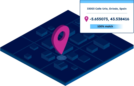
Granularity up to street level
Coordinates for UNLOCODEs
SOLUTIONS
Typical use cases for international geocoding
Overcome the challenges of international geocoding
Limited coverage

Unreliable sources
Poor data quality
Low match rate
Multiple address formats
MAIN FEATURES
Global coverage with local precision
High granularity
Our database enables accurate geocoding of Postcodes, regions, cities, streets, and UNLOCODEs.

Global coverage
Reliable and up-to-date data for geocoding even in difficult geographies such as China, the UK, Russia, or Brazil.
247 countries in a standardized database

Unmatched data accuracy
Our advanced data pipelines capture, clean, format, and integrate new data consistently. Our proprietary data-mastering processes guarantee reliable coordinates up to street level.

Trusted by industry leaders
Join more than 100 enterprise clients who trust GeoPostcodes for their location data
Anjo Grebe
Consultant

Dr. Peter Wild
Managing Partner

Kousha Mazloumi
Director of Data Science
Kousha Mazloumi
Director of Data Science

William Chao
Product Owner of Geographic Information Services

Kate Kilby
Senior Product Manager

Dave Hamm
Project Manager


Kavian Ranjbar
Data Governance Specialist

Nick Beaugié
Senior Software Engineer
Self-hosted data
Get our geocoding data into your IT infrastructure. No need to set up, audit, and maintain a connection to a third-party service. Perfect for use cases that require big amounts of requests.

Rich attributes
Our geocoding data can be enriched with country-specific information, population, multi-language support, UNLOCODEs, IATA codes, and time zones. Perform dynamic visualizations and reliable distance calculations.

Enterprise expert consultancy
Our team has 15 years of experience in Enterprise integration with an in-depth knowledge of each country's postal structure.
Reduce integration time by 30%

WHY GEOPOSTCODES
Why rely on our international geocoding database?
 | Third-party API | |
|---|---|---|
| Price | FIXED COST | PER QUERY |
| Control over security, speed and latency | FULL | NO |
| Customization | FULL | LIMITED |
| Analytics | FULL | LIMITED |
| Connection to 3rd party required | NO | YES |
| Integration into your software | FULL | NO |
Why choose GeoPostcodes

Global coverage
Complete coverage across 247 countries, including hard-to-source geographies like China, Japan, Brazil, and Russia.

Highest quality
Built on extensive, authoritative sourcing with robust data engineering and quality control. Standardized and up-to-date.

Expert Consulting
With 15 years of experience, we guide your implementation and deliver data in the format that fits your system.
Our international geocoding articles


Frequently Asked Questions
Accuracy in international geocoding depends on the quality of the underlying latitude and longitude coordinates used for each location. GeoPostcodes relies on authoritative sources and consistent coordinates to ensure reliable geographic coordinates, even in countries with fragmented postal systems.
To understand why Postcode formats differ across markets—and how this affects geocoding accuracy—you can explore our Global Guide to Postcode Formats.
You can perform reverse geocoding by converting latitude and longitude coordinates into readable postal addresses. Modern geocoding services use high-quality address data to return structured results, making reverse geocoding useful for logistics, compliance, and proximity-based applications across borders.
If you want to see how coordinates are handled programmatically, our tutorial on Python Postcode validation illustrates how structured geodata can be used in geocoding workflows.
Yes, geocoding data supports ad targeting and radius searches by transforming address data into precise geographic coordinates. With standardized inputs, organizations can geocode addresses, calculate coverage zones, and run audience segmentation using clean datasets suited for global use.
For a deeper look at how businesses use Postcode-based geography in segmentation, see our guide to Postcode Analysis.
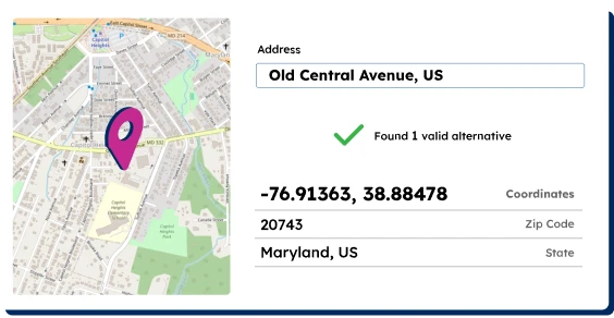
You can run address validation on postal addresses to ensure that spelling, postal codes, and administrative divisions are correct before geocoding. Proper address validation improves accuracy and prevents mismatched locations when processing multiple addresses.
If you want to understand the principles behind cleaning and preparing addresses, see our guide on Address Standardization.
Yes, you can use batch geocoding to convert multiple addresses into coordinates at scale. This method helps teams standardize global datasets, enrich address data, and prepare records for mapping or analytics. Bulk processing ensures consistent outputs across international regions.
To see an applied example of processing large sets of geographic data, our article on Storing Postcode Data in SQL provides helpful patterns.
To geocode addresses effectively, you need clean address data, correct postal addresses, and access to consistent geocoding services. High-quality inputs ensure accurate matching, reduce exceptions, and strengthen your international geocoding workflows.
You can learn more about how different countries structure postal data in our guide on International Address Formats.
Yes, you can geocode addresses from any region by using standardized input formats and clean postal addresses. Consistent formatting ensures that international datasets align correctly during processing and improves cross-border geocoding accuracy.
A useful supporting resource is our article that explains Postcode vs Postcode differences, helping teams align global formats.
A batch geocode workflow lets you process large datasets at once, unlike Google Maps, which focuses on single-record queries. Batch processing also helps you match each point to the nearest street address, making it useful for enterprise-scale logistics, compliance, and mapping operations.
For more context on how enterprise geocoding differs from consumer-grade tools like Google Maps, see our article on Enterprise Location Data Management.