

Key takeaways
- GeoAI combines location data with AI to transform business decision-making processes.
- From address standardization to market analysis, GeoAI solves real-world business challenges.
- Implementation requires quality data, integration with existing tools, and proper staff training.
- Emerging trends include real-time analysis, IoT integration, and natural language interfaces.
Introduction
Remember when location intelligence just meant using paper maps with pens? We’ve come a long way since then. The shift from those static tools to today’s advanced GeoAI systems is one of the biggest changes in business intelligence.
At first, companies used physical maps and basic demographic data to guide location decisions. The process was manual, time-consuming, and limited in scope.
Then came digital maps and GIS (Geographic Information Systems), which let businesses create computer-based maps and do complex analysis. Much better, right? But they still needed a lot of human input and technical skills.
Things really changed when artificial intelligence and machine learning were added to location technology in the 2010s. Suddenly, systems could learn from data, spot patterns, and make predictions on their own—like Amazon’s logistics AI that began routing millions of packages more efficiently by 2025, or Walmart’s recent hexagonal grid mapping system that expanded delivery reach to 12 million additional households.
Today’s GeoAI systems can pull in data from many sources, such as satellite images and traffic reports. They use powerful algorithms to turn that information into real business insights.
For example, Planet Labs combines satellite imagery with AI to help agricultural companies monitor crop health across thousands of acres, while UPS’s ORION system processes real-time traffic data, weather conditions, and delivery schedules to optimize routes for 55,000 drivers daily.
In this article, we’ll explain what GeoAI is, how it’s used, and why it matters, especially if your business depends on accurate, up-to-date location data.
💡 The power of modern GeoAI systems lies in having access to high-quality location data as their foundation. For over 15 years, we have created the most comprehensive worldwide ZIP code database, from 1,500+ sources and always up-to-date—the kind of multi-source data integration that makes GeoAI powerful. Browse GeoPostcodes databases and download a free sample.
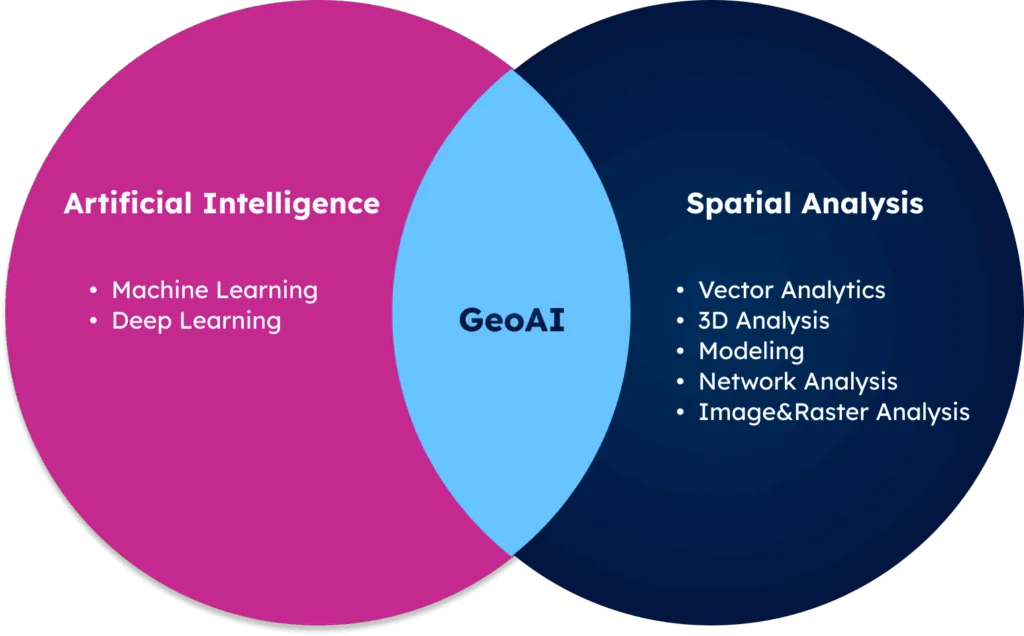
What is GeoAI?
Geospatial artificial intelligence (GeoAI) combines location data with artificial intelligence (AI) techniques to analyze geospatial patterns and generate insights.
It uses machine learning, natural language processing, and computer vision to process maps, satellite imagery, and geographic datasets, helping businesses and governments understand the real-world issues and opportunities.
The power of GeoAI comes from its ability to analyze billions of data points quickly, spot patterns people might miss, and get smarter over time. It’s changing how people use geographic information, from market analysis to targeting customers, operational improvement, and urban planning.
It’s no longer just about showing where things happen, but understanding why they happen, predicting what’s next, and helping businesses make smarter decisions based on location.
How is GeoAI Used for Business?
To fully understand GeoAI’s impact on business, you need to look at how it works, how it integrates with existing tools, and what it takes to implement it successfully. The sections below break down these key areas and show you how GeoAI fits into the broader business landscape.
How GeoAI Systems Work
Well, the technical side can seem complex, but don’t worry, the basic ideas are easy to follow, even if you don’t have a technical background.
First of all, you will need to know that GeoAI is built on three main parts: geospatial data, AI algorithms, and systems that process them all.
The location data could be anything from simple map points to detailed shapes that define regions, plus raster data for comprehensive spatial analysis.
Point data includes customer addresses, store locations, or GPS coordinates from delivery vehicles. Vector polygons define administrative boundaries like postal codes, sales territories, or market areas—essential for demographic analysis and territory planning.
Raster data from satellite imagery provides continuous coverage for analyzing land use patterns, population density heat maps, or environmental factors that affect business operations. For instance, a retail chain might combine point data (competitor locations), polygon data (ZIP code boundaries with demographic profiles), and raster data (foot traffic density from mobile phone signals) to identify optimal expansion sites.
This multi-layered approach gives businesses the complete spatial picture needed for informed decision-making.
Once having geospatial data, AI models (mostly machine learning) analyze it to find patterns, make predictions, and provide insights.
Behind the scenes, all this requires some serious computing power, often powered by the cloud and specialized geospatial databases.
And modern GeoAI systems use a mix of AI techniques depending on what they’re trying to do.
For analyzing location-based customer feedback and social media, they rely on natural language processing (NLP). It helps systems understand sentiment about places, businesses, or events in different areas. For example, NLP can process restaurant reviews to identify neighborhoods with positive sentiment toward cuisine types or analyze posts about shopping districts.
To spot patterns across geographic areas, GeoAI uses computer vision, which is also used in image recognition. It helps the system “see” spatial patterns, such as business clusters, land use changes, or road layouts that affect traffic. These insights reveal relationships that raw data alone might not show.
Predictive analysis in GeoAI often uses machine learning models built to understand spatial relationships. These models go beyond typical predictions by factoring in that nearby places usually influence one another.
For example, proximity analysis can help figure out how a new store might perform based on nearby businesses that attract similar customers. Clustering algorithms can spot areas where certain customer types or business activities are concentrated.
However, remember that when using GeoAI, spatial data comes in many formats. The inconsistency in data format can lead to technical issues. Leading GeoAI systems use quality reference databases and build smart data pipelines that keep maps and location information up to date.
Integrating GeoAI with Business Intelligence Tools
The most successful companies don’t treat GeoAI as a separate tool; they build it into their entire decision-making process.
It is because GeoAI becomes more powerful when connected to broader business intelligence tools.
Modern BI platforms like Power BI, Tableau, and Qlik already support maps and basic geospatial tools. But when you combine them with GeoAI, you unlock deeper insights.
For example, a retail chain might find that stores located near certain types of businesses consistently perform better. These patterns are easy to miss without location-based analysis powered by AI.
GeoAI also helps you see the full picture. If sales are down in one region, traditional reports might stop there. But GeoAI can show why—maybe it’s due to new construction nearby, changes in traffic flow, or a new competitor moving in.
To get the most out of GeoAI, it should connect with more than just your BI tools. Linking it to your CRM helps sales teams see where customers are concentrated and plan territories more effectively.
Connecting GeoAI with your ERP system helps operations teams manage supply chains based on location.
Even marketing platforms can use GeoAI to send highly targeted messages based on neighborhood data.
Many businesses start small with one GeoAI project and expand as they see results. This step-by-step approach delivers quick wins and lays the foundation for a full location intelligence strategy.
Implementing GeoAI for Businesses
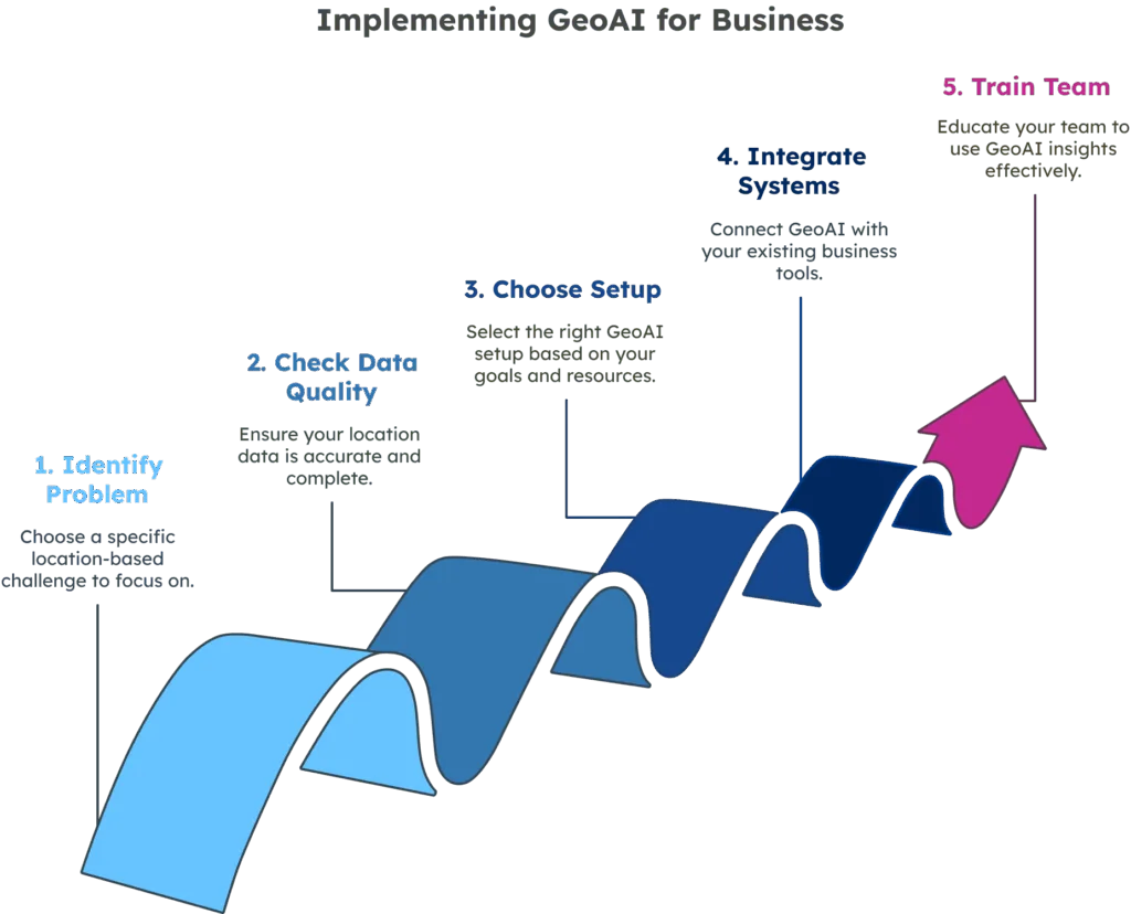
Getting started with GeoAI doesn’t have to be difficult. With the right plan, businesses of any size can begin using it to improve decisions and operations. Here’s a simple roadmap to help you get started.
- Start by choosing a specific problem in which location plays a major role.Focus on a clear challenge, such as making deliveries more efficient, picking better store locations, or helping your sales team manage territories. Solving a real business problem first helps you see quick, measurable results.
- Next, check the quality of your location data. Begin with a data review to see what you have. You need accurate reference data to ensure your GeoAI system produces reliable insights.
- Choose the right setup based on your goals and resources. This is where many businesses get stuck, so let’s break down your main options:
Cloud-Based GeoAI Platforms:
– Planet Labs: Satellite imagery platform with AI-powered analysis for agriculture, forestry, and urban planning applications
– IBM Watson Studio: Geospatial analytics platform that combines location intelligence with AI modeling capabilities
Custom Development Options:
– Open-source tools: PostGIS, QGIS, and Python libraries (GeoPandas, Folium) for businesses with technical teams
– Hybrid approach: Combining existing platforms with custom development for specific needs
The choice depends on your budget, technical expertise, and specific use case. - Make sure your GeoAI system can connect to your existing tools. GeoAI’s real power comes when it links to your CRM, ERP, or analytics platforms. Plan for integration early and choose a system with robust APIs and data-sharing options. Look for platforms that offer pre-built connectors to popular business tools like Salesforce, SAP, or Tableau.
- Finally, help your team use GeoAI effectively. Offer training so staff can read maps, understand the data, and turn insights into action. That’s how GeoAI becomes part of your business’s thinking and working.
Why is GeoAI Used for Business?
The use of GeoAI can bring unexpected benefits to different sectors. In this section, you will also see in detail the various ways in which it can add value to businesses.
GeoAI for Address Data Accuracy
Managing address data is a constant challenge for businesses operating in multiple countries in logistics, e-commerce, and CRM systems. While GeoAI offers valuable capabilities for address processing, it fundamentally depends on high-quality reference data to function effectively.
Among all the challenges, the biggest one is the varying address formats.
Think about all the ways addresses enter your system: online forms, customer calls, or input from your sales team. Every entry presents a chance for mistakes, which can lead to failed deliveries, lost messages, and wasted time.
In Japan, addresses start with the postal code and region, while in the U.S., they begin with the street number. Having accurate and comprehensive reference databases, GeoAI geocoding and address standardization systems can recognize these patterns and convert them into a consistent format.
Language differences add another layer of complexity.
A city might have names in different languages, or the same address might appear in multiple spellings. Natural language processing algorithms can help map multilingual place names to the same geographic entity. But they require extensive multilingual location databases as their foundation to work accurately.
💡 GeoPostcodes offers a comprehensive global ZIP Code and address database in the official languages of 247 countries. Our standardized and unified data structure ensures accessibility and superior data accuracy across countries.
GeoAI is also great for cleaning up existing address data.
Advanced algorithms, combined with high-quality, professionally maintained location data sources, can identify duplicates (e.g., “Main St.” vs. “Main Street”), flag missing components, and correct errors at scale. This is a common application in data quality management and customer relationship management (CRM) systems.
GeoAI for Location Insights
Postal codes carry a lot of geographic information. These codes represent specific areas, and when properly analyzed, they reveal valuable insights about markets, customers, and operations.
For example, GeoAI can connect a basic list of postal codes with other data, such as demographics, income levels, shopping habits, and even cultural preferences. This gives businesses a much deeper understanding of their customers, not just where they live but why they would buy.
GeoAI also expands what postal codes can do. It helps sales teams plan territories by combining postal zones with travel times and customer density.
GeoAI for Business Decisions
For business leaders, location-based decisions range from where to expand to how to run daily operations. Using GeoAI, companies can look at all the following factors at once.
- Market planning: GeoAI can identify trends across regions while adjusting for local differences, helping companies confidently expand into new markets. These insights guide smarter market planning and support growth in a rapidly changing world.
- Site Selection: GeoAI looks at foot traffic, local business growth, demographic shifts, neighborhood development, and even social media sentiment around an area.
- Supply Chain Efficiency: GeoAI analyzes postal code distribution patterns to suggest the best warehouse or fulfillment center locations. By combining travel times, traffic conditions, and customer density, GeoAI helps companies streamline delivery networks and reduce costs.
- Customer Behavior Analysis: GeoAI connects postal codes to lifestyle data, and businesses can uncover patterns in consumer preferences, spending habits, and even cultural factors that influence buying decisions.
- Viability Assessment through Pattern and Predictive Modeling: Businesses can spot shifts in population movement, economic growth, or customer demand up to 12–18 months in advance. This forward-looking analysis helps companies plan ahead, not just react.
- Pattern recognition: GeoAI helps detect fraud through unusual shipping behaviors or forecast which sales territories are underperforming.
GeoAI in Real-World Applications
GeoAI is already being used by smart companies to improve operations and stay ahead of the competition. These real-life examples show how geospatial AI is making a real impact across different industries.
- Retail: Walmart used hexagonal grid mapping to expand delivery reach to 12 million additional households and enable multi-store order fulfillment, winning the 2023 Franz Edelman Award for Operations Research excellence (Retail TouchPoints, 2025; Walmart Commerce Technologies).
- Logistics: The ORION route optimization system of UPS saves $400 million annually, reduces fuel consumption by 10 million gallons, and cuts 100 million miles from delivery routes each year across 55,000 drivers (Best Practice AI, UPS Case Study; BSR Technology Case Studies).
- Finance: Government Employees Credit Union used location intelligence and predictive modeling to identify new neighborhoods with strong demand for their services. Since 2025, GECU has collaborated with DBSI on over 20 branch optimization projects, resulting in 54.7% membership growth while maintaining 100% in-branch self-service adoption rates (The Financial Brand, 2025).
- Healthcare: Researchers used GeoAI to analyze convolutional neural networks on satellite imagery to map disease patterns. They linked ZIP code-level Medicare data with environmental exposures to identify mortality risks across populations.
The Future of GeoAI
GeoAI is evolving fast, with new tools making it even more powerful for businesses. Staying on top of these trends helps companies stay competitive and get more out of location data.
- Real-time GeoAI: Modern systems analyze live location data, not just the past. This helps businesses adjust delivery routes, staffing, or emergency responses instantly.
- IoT (Internet of Things) with GeoAI: Smart devices with GPS and sensors feed rich data into GeoAI. Retailers can track how long customers stay and what they interact with, improving layouts and product placement.
- Augmented reality (AR) with GeoAI: uses GeoAI for indoor navigation, real-world previews of buildings, and guided repair instructions based on location.
- New natural language tools: They are making GeoAI easier for everyone to use. Just ask simple questions like “Which areas are underperforming?” and get a visual answer—no GIS skills required.
- Edge computing: Devices can now process GeoAI data on-site, reducing lag and working even without strong internet. It’s ideal for mobile teams and autonomous systems.
Conclusion
GeoAI algorithms for address standardization, geocoding, and location analysis are powerful, but they’re deeply connected to the quality of their underlying data. You can have the most advanced AI models, but without accurate reference data covering global address formats, postal codes, and geographic boundaries, the results will be unreliable.
Most companies lack in-house expertise to build advanced GeoAI systems from scratch, nor do they have access to the global, multilingual location datasets these systems require to function properly.
That’s where location intelligence providers come in. With a solid data foundation in place, teams can focus on developing the AI components that solve their unique business challenges.
For over 15 years, GeoPostcodes has offered the most complete global location data, helping businesses build reliable GeoAI solutions with accurate geographic insights. We invite you to browse our databases for free to see how they can power GeoAI implementation. Contact us now or request a quote here.
FAQ
What is the use of GeoAI?
GeoAI methods utilize AI techniques and advanced tools, such as spatially explicit models and the segment anything model with building footprints and training data, to enable object detection, object tracking, change detection, feature extraction, pixel classification, and high-resolution image segmentation from satellite images and remote sensing data.
Apart from this, it uses geospatial information and geographic information science for big data analysis, disaster response, and emergency management.
What does the acronym GeoAI stand for?
GeoAI stands for Geospatial Artificial Intelligence. It uses machine learning algorithms and deep learning tools to analyze tabular data, overhead imagery, and lidar point clouds.
What is geospatial AI?
Geospatial artificial intelligence (GeoAI) is the fusion of AI (Artificial Intelligence) with geospatial data and technology. It helps businesses and organizations understand real-world patterns, risks, and opportunities using data tied to locations, like postal codes, addresses, and boundaries.
How can AI be used in GIS?
AI in GIS, through geospatial artificial intelligence and machine learning, enhances geospatial data interpretation using advanced spatial analysis for smarter, faster geospatial decision-making.
How to learn GeoAI?
To learn GeoAI, start with GIS and AI basics (such as knowing machine learning techniques and deep learning frameworks). Then you can explore online courses, tutorials, and tools like Python, QGIS, and machine learning libraries focused on spatial data to learn how to use the training datasets.
What is GeoAI in health used for?
GeoAI in health is used to map disease patterns, improve emergency response, plan healthcare access, and target interventions based on location and population data.
How does GeoAI detect spatial patterns?
GeoAI leverages machine learning and deep learning techniques to identify spatial patterns within geospatial data. During the training process, these algorithms, such as artificial neural networks, analyze high spatial data, satellite imagery, and GPS data to automatically recognize recurring spatial arrangements, spatial patterns, and relationships.
This process enables the extraction of meaningful insights, the prediction of outcomes, precise geospatial analysis, and modeling.
What are the advantages of GeoAI over traditional methods?
Apart from faster analysis, real-time insights, better pattern detection, and predictive capabilities, deep learning packages serve many other fields. GeoAI uses a deep learning model and other tools to analyze vast amounts of satellite imagery and imagery data for models in damage assessment and potential applications.