
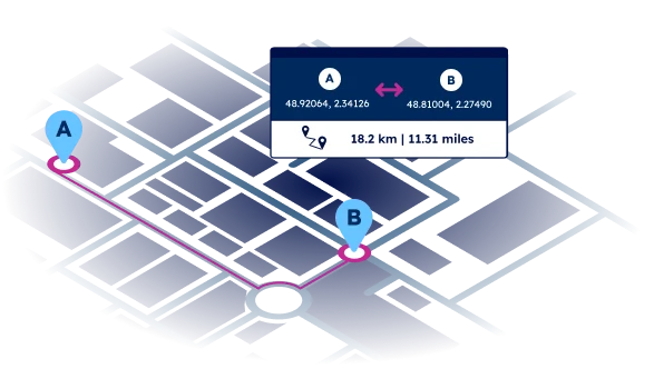
Accurate distance calculation between ZIP codes
Geocoded data for accurate distance calculation and radius search.
SOLUTIONS
Get the right data for your use case
Optimize your shipping operations
Design and optimize your distribution network, plan your pick-up and drop-off locations, calculate CO2 emissions, and improve visibility.
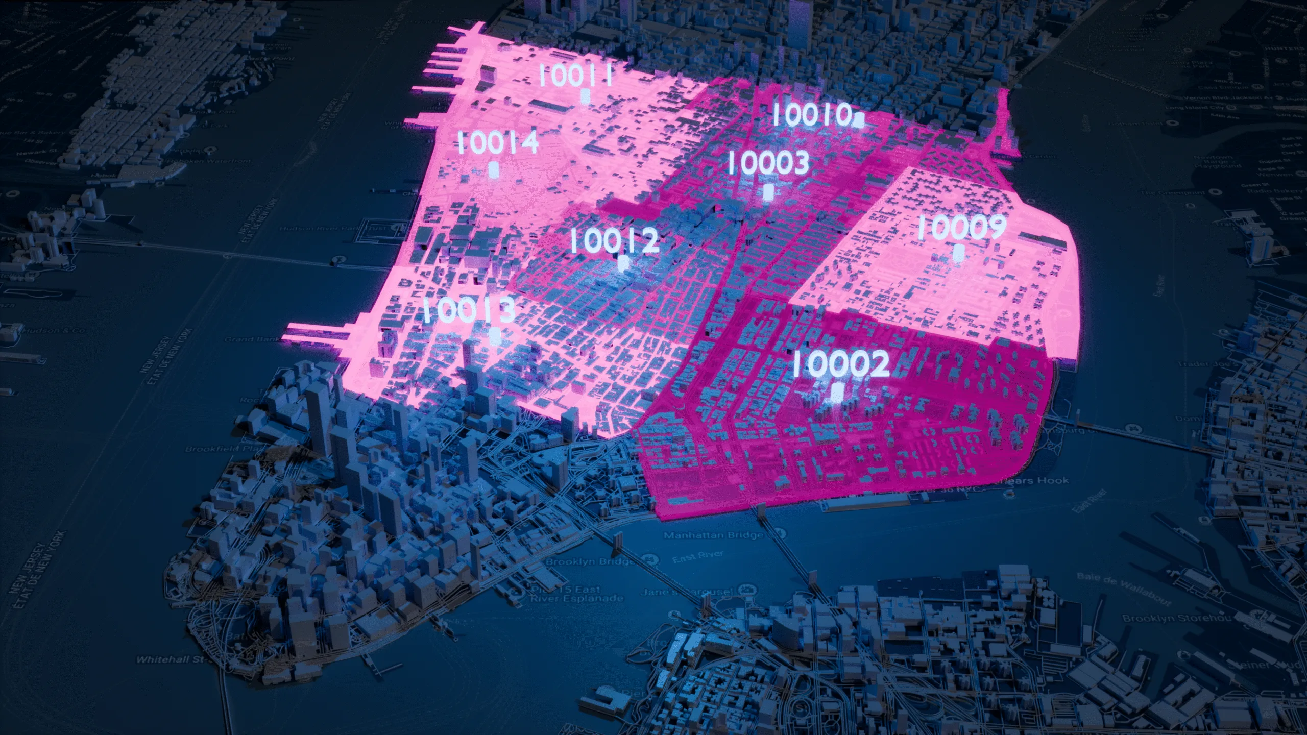
Radius Search
Match locations within a certain perimeter based on reliable geocoordinates. Target customers with geofenced ads, map delivery zones for logistics companies and organize localized teams.
Distance between supply and demand
Leverage accurate geocoded data to provide your users with the search experience they deserve.
Ad targeting
Design custom areas for geofencing and targeted advertising. Obtain actionable insights into customer behavior including geographical distribution and travel distances.
Map reliable risk areas
Ensure a proper identification of addresses at risk, determine the extent of the damage and identify the affected zip codes with precision.
Trusted by industry leaders
Join more than 100 enterprise clients who trust GeoPostcodes for their location data
Anjo Grebe
Consultant

Dr. Peter Wild
Managing Partner

Kousha Mazloumi
Director of Data Science
Kousha Mazloumi
Director of Data Science

William Chao
Product Owner of Geographic Information Services

Kate Kilby
Senior Product Manager

Dave Hamm
Project Manager


Kavian Ranjbar
Data Governance Specialist

Nick Beaugié
Senior Software Engineer
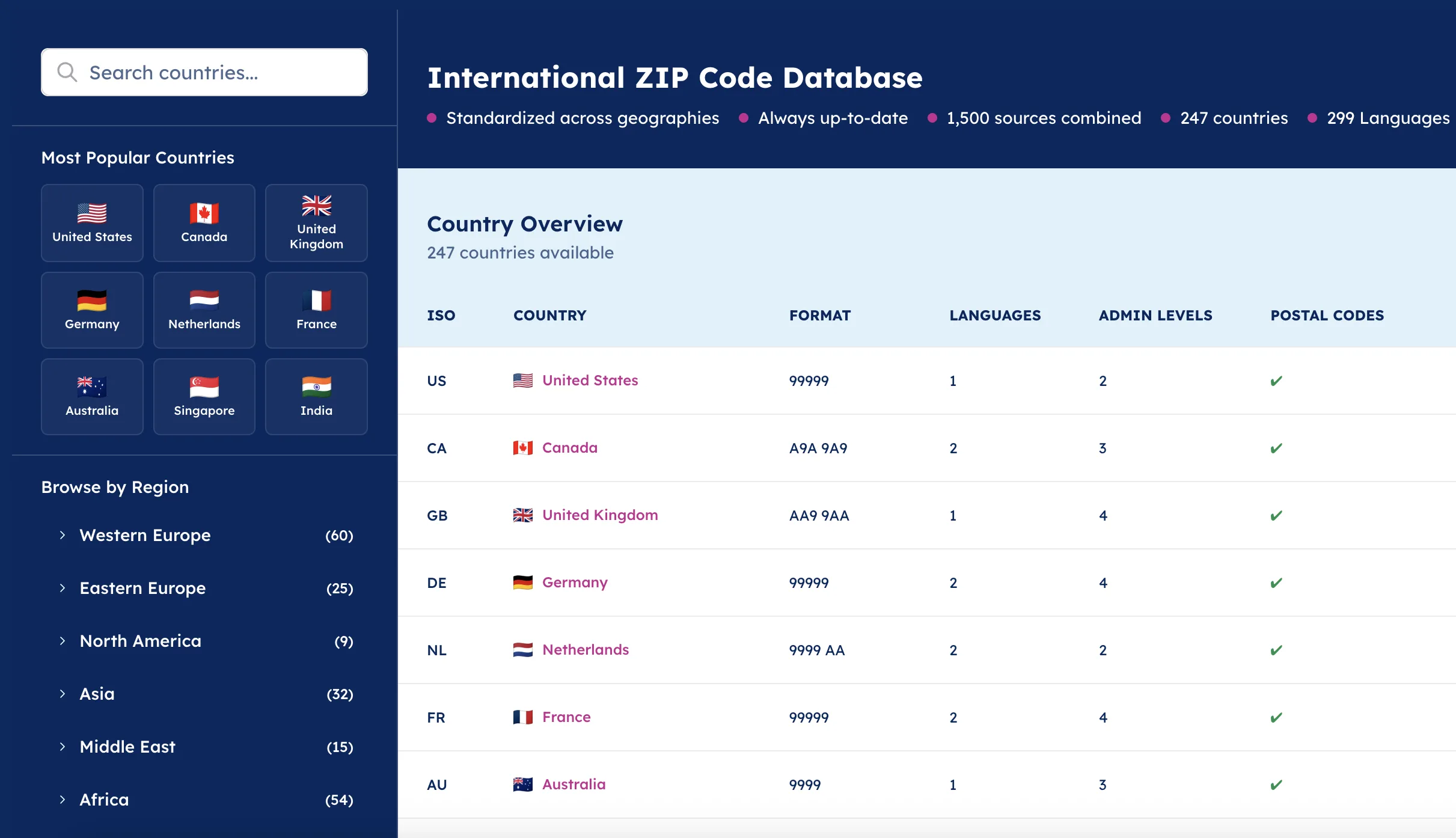
Why use our data to calculate distance between zip codes?
Global coverage
Reliable and up-to-date data for geocoding even in difficult geographies such as China, the UK, Russia, or Brazil.
247 countries in a standardized database
Reliable geocoordinates
All the geocoded global data your local team will appreciate. Our database allows precise geocoding up to street level, including zip codes, regions, cities and streets.

Additional attributes
The data can be enriched with country-specific information, distance to the center of the city, UNLOCODE and IATA codes, port terminal specifications, and time zones.

Why choose GeoPostcodes

Global coverage
Complete coverage across 247 countries, including hard-to-source geographies like China, Japan, Brazil, and Russia.

Highest quality
Built on extensive, authoritative sourcing with robust data engineering and quality control. Standardized and up-to-date.

Expert Consulting
With 15 years of experience, we guide your implementation and deliver data in the format that fits your system.
Our distance calculation articles


Frequently Asked Questions
Global distance calculation is based on measuring the curve of the earth’s surface between two points. Most systems use straight-line distance or great-circle distance depending on how precise the measurement needs to be. The haversine formula is the most common method for computing the shortest path between two coordinates.
For a practical example of how these calculations work in code, see How to Calculate Distance Between Two ZIP Codes in Python.
The haversine formula is essential because it accounts for the Earth’s curvature, delivering more accurate distance values between two addresses. Unlike flat straight-line approximations, it returns the shortest great-circle path across the earth’s surface—making it reliable for calculating distance in kilometers between regions, postal areas, and major cities.
Developers working with address-based inputs can explore a detailed walkthrough in How to Calculate Distance Between Two ZIP Codes in Python.
A distance calculator uses straight-line methods for simple estimates and great-circle calculations for precise outputs. It evaluates the latitude and longitude differences between two points and applies formulas like haversine to return accurate results in kilometers.
For examples of both methods in action, see How to Calculate Distance Between Two ZIP Codes in Python.
Yes. Digital maps and route planners can calculate the distance between two addresses using road networks or straight-line distance. Professional distance calculators also support great-circle paths for greater precision when required.
To compare different mapping approaches, explore Zip Code Analysis: How to analyze business data using ZIP codes.
Distance calculation remains the same worldwide: the tool compares coordinates and computes the shortest path using formulas like haversine. In large countries with uneven terrain—such as the Democratic Republic of the Congo—accurate coordinate data ensures reliable results.
To understand the importance of clean global geodata, see Enterprise Location Data Management Explained.
Some applications only need quick approximations, where straight-line distance is acceptable. Others—such as aviation, cross-border logistics, or long-distance calculations—require the accuracy of great-circle math. A distance calculator may begin with a straight-line preview and refine the result with haversine for precision.
For more context on working with global postal and coordinate data, see Postal Boundaries and ZIP Code Formats.
Route planners rely on road networks embedded in the map instead of simple straight lines. They still reference geographic coordinates and compute distance in kilometers, but they measure travel paths rather than geometric separation. For international routing, these tools often combine routing engines with the same coordinate principles used in distance calculators.
To learn how structured location data supports routing and logistics systems, see ERP & TMS Integration: Step-By-Step Guide.
To compute distance from raw latitude-longitude values, a distance calculator applies the haversine formula or a similar great-circle algorithm. This converts angular separation into kilometers and enables analysts to measure straight-line or shortest-path distance from coordinate pairs alone.
For an applied coordinate-based example, see How to Calculate Distance Between Two ZIP Codes in Python.
Yes—many tools display straight lines between two points as a visual approximation of the shortest distance. However, for global measurements or long-distance scenarios, great-circle calculations provide more accurate results because they account for the Earth’s curvature.
For guidance on mapping accuracy and region-based calculations, explore How to Create a ZIP Code Map.
Great-circle distance represents the mathematically shortest route across the earth’s surface between two points. It’s essential for aviation, maritime transport, and long-haul planning because it avoids distortions found in straight-line map projections. Distance calculators using haversine or similar methods provide accurate results even across thousands of kilometers.
For additional context on geographic structures across regions, see What Is Location Intelligence?.