

OpenStreetMap Alternative
Globally standardized ZIP code, address and boundary data curated from authoritative sources
Reasons to choose GeoPostcodes over OpenStreetMap
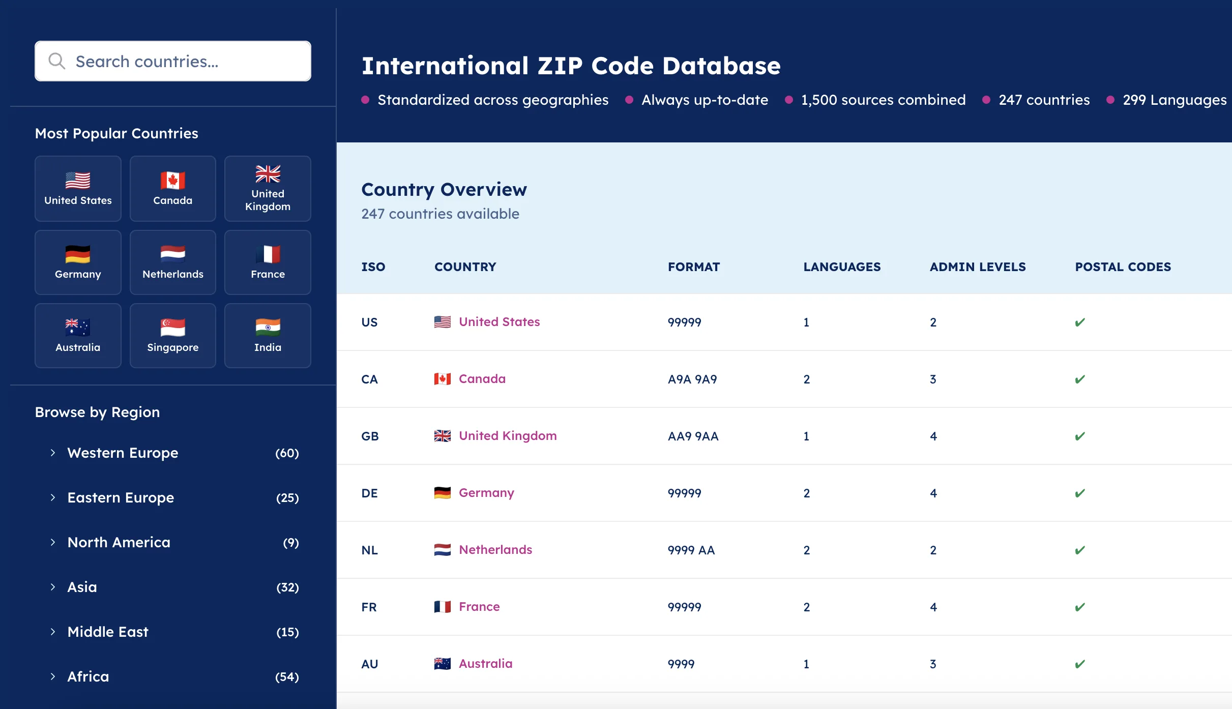
Standardized global structure
Dedicated expert consulting
Authoritative official sources
 | ||
|---|---|---|
| Data Sources | 1,500 official sources including postal operators and governments | Crowdsourced database maintained by a global community |
| Commercial Use | Fixed annual licensing model tailored to your scope | Open Database License (ODbL) with source credit requirement |
| Data Structure | Unified global schema with standardized administrative levels | Data structure varies by contributor and country |
| Data Coverage | Global coverage across 247 countries, including hard-to-source geographies | Global coverage with varying levels of detail |
| Customer Support | Enterprise consultancy included, with in-house GIS specialists | Community forums and public documentation |
Why choose GeoPostcodes as the OpenStreetMap alternative
Flexible implementation and integration
Integrate self-hosted global location data directly within your systems. Adapt the implementation to your existing architecture.

Standardized data
Integrate global location data with a standardized structure and unified file formats. Benefit from consistent column titles, attribute naming and data models across all countries.

Worldwide coverage
Get accurate and up-to-date global address data, including street names, ZIP codes, cities, administrative divisions and official address formats for each country.
First-party data and in-house expertise
Rely on a first-party data provider that curates and maintains datasets internally. In-house GIS specialists support your integration and ongoing usage, with direct access to expert guidance.

Trusted by industry leaders
Join more than 100 enterprise clients who trust GeoPostcodes for their location data
Anjo Grebe
Consultant

Dr. Peter Wild
Managing Partner

Kousha Mazloumi
Director of Data Science
Kousha Mazloumi
Director of Data Science

William Chao
Product Owner of Geographic Information Services

Kate Kilby
Senior Product Manager

Dave Hamm
Project Manager


Kavian Ranjbar
Data Governance Specialist

Nick Beaugié
Senior Software Engineer
Get our data now
Frequently Asked Questions
Yes, Mapbox uses OpenStreetMap as a primary data source but enhances it with custom styling, APIs, and tools. While useful for visualizations, it inherits OSM’s data limitations.
GeoPostcodes uses 1,500+ official sources to deliver verified, standardized geospatial data with a unified structure and regular updates. It offers tailored licenses and dedicated expert support. In contrast, OpenStreetMap relies on crowdsourced data, has non-standard formats, and variable update frequency.
OpenStreetMap is a free, open-source project that offers open-source maps via its API. Mapbox builds on that, adding styled map services and tools for geographic coordinates. However, OSM has limitations in data consistency for specific categories and street maps.
While free and supported by the OpenStreetMap community, OpenStreetMap has limitations in data accuracy, specific categories, and street maps. Usage restrictions and limited base map options also affect broader geospatial data applications, including Google Earth.