

To calculate the distance between ZIP Codes in Excel, match each GeoPostcodes’ provided ZIP Code to its latitude and longitude coordinates, convert those values to radians, and apply the Haversine formula to measure straight-line distance.
Key takeaways
- ZIP Code distance in Excel is calculated using the Haversine formula, which measures straight-line (“as-the-crow-flies”) distance between coordinates.
- You need a ZIP Code database with accurate latitude and longitude values, such as data from GeoPostcodes.
- Latitude and longitude values must be converted from degrees to radians before applying the formula.
- Results represent straight-line distance, not driving or travel routes, and can be expressed in kilometers or miles.
- Accuracy depends heavily on up-to-date ZIP Code centroid data, especially for large or rural ZIP Codes.
Introduction
Looking to calculate distances between ZIP Codes? Whether you’re optimizing delivery routes, conducting market analysis, or simply satisfying your geographic curiosity, you’ve come to the right place. The process is surprisingly straightforward, and we’re here to guide you through every step with our comprehensive, easy-to-follow tutorial.
💡 Browse GeoPostcodes’ ZIP Code database, built from over 1,500 authoritative sources. Enhance your distance calculations and logistics analysis with highly accurate, ZIP-Code-level geographic coordinates. You can download a free sample here.
Required data for distance calculation
Before diving into calculations, we need to gather the tools mentioned above, essentially:
- A database containing ZIP Codes with their corresponding latitude and longitude coordinates, such as the ZIP Code Lookup tool.
- Excel (or Google Sheets) is our calculation engine.
- The Haversine formula implementation acts as your distance-measuring algorithm.
Understanding the Haversine Formula
The Haversine formula in Excel calculates the shortest distance between two points, taking into account Earth’s curvature to provide accurate “as the crow flies” distances:
=ACOS(SIN(lat1)*SIN(lat2)+COS(lat1)*COS(lat2)*COS(lon2-lon1))*6371
Formula Breakdown:
- lat1, lon1 = Coordinates of your first ZIP Code (in radians)
- lat2, lon2 = Coordinates of your second ZIP Code (in radians)
- 6371 = Earth’s radius in kilometers (use 3959 for miles)
Step-by-step implementation
Ready to put theory into practice? To start, let’s open the GeoPostcodes ZIP Code Lookup tool.
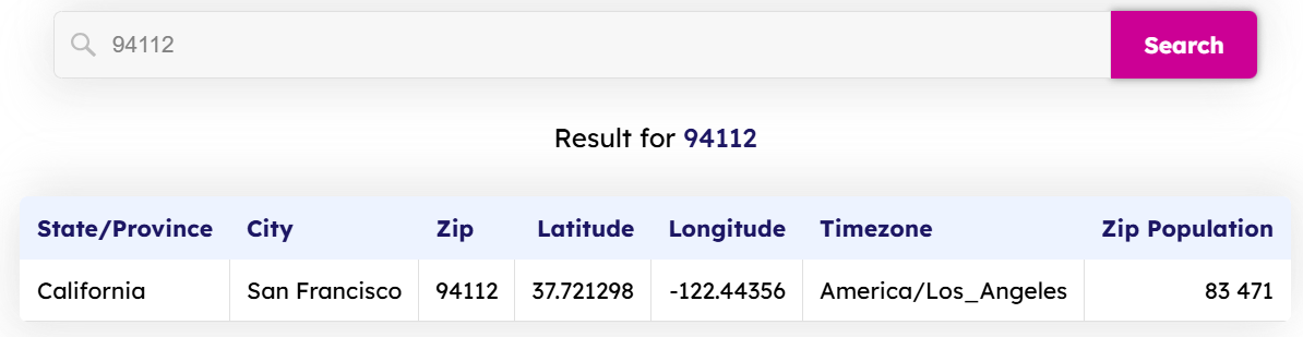
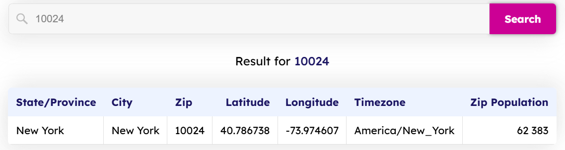
In the search bar, type the ZIP Codes of your interest and observe the attributes that are available. In our example, we will pick 94112 (located in San Francisco, USA) and 10024 (in New York, USA):
Now, we can follow a few simple steps to achieve our objective:
Step 1: Organize the data by arranging the ZIP Codes and their coordinates in clearly labeled columns.
Our formatted Excel table now looks like this:
| STATE/PROVINCE | CITY | zip | latitude | longtitude | timezone | zip population |
|---|---|---|---|---|---|---|
| California | San Francisco | 94112 | 37.721298 | -122.44356 | America/Los_Angeles | 83471 |
| New York | New York | 10024 | 40.786738 | -73.974607 | America/New_York | 62383 |
Step 2: From the attributes that are offered by the GeoPostcodes ZIP Code Lookup tool, we will only need ZIP, Latitude, and Longitude. Convert your latitude and longitude values from degrees to radians using Excel’s built-in formula: =RADIANS(degree_value). This conversion is crucial because the Haversine formula uses radians, not degrees.
| ZIP | LATITUDE | LONGTITUDE | LATITUDE (rADIANS) | LONGTITUDE (RADIANS) |
|---|---|---|---|---|
| 94112 | 37.72 | -122.44 | 0.66 | -2.14 |
| 10024 | 40.79 | -73.97 | 0.71 | -1.29 |
Now that we have our sample dataset ready, we can proceed with the calculations.
Step 3: Paste the Haversine formula in the cell where you want to store the results and replace the values with your data. In our example:
=ACOS(SIN(0.66)*SIN(0.71)+COS(0.66)*COS(0.71)*COS(lon2-(-2.14)))*6371
The result is 4134.08 kilometers.
Step 4: Now that the calculation is complete, we can format and convert the results to the desired units: meters, kilometers, miles, or any other unit.
Limitations and Considerations
Every tool has its limits, and ZIP Code distance calculations come with important caveats.
- ZIP Code centroids provide approximations of entire areas. Large rural ZIP Codes might have centroids far from where most residents live.
- These calculations represent straight-line distances, similar to drawing a line with a ruler across a map and ignoring the realities of road networks or air travel. This limitation can be mitigated by performing Network Analysis using ArcGIS, using, for example, accurate postal boundaries data from GeoPostcodes. This approach offers a more realistic and reliable alternative for modeling real-world scenarios, thereby enhancing the quality of spatial insights and decision-making.
- These calculations assume that Earth is perfectly spherical, though the difference is negligible for most business applications.
Tips for Accurate Calculations
Obtaining precise distance measurements requires meticulous attention to detail and high-quality data. These practical tips will help you avoid common pitfalls and ensure reliable results in your calculations:
- Verify your coordinate sources: Not all ZIP Code databases are created equal. Cross-reference your latitude and longitude data with reputable sources to avoid errors that will compromise your entire analysis.
- Use bulk calculations for efficiency: When processing hundreds or thousands of ZIP Code pairs, set up your formulas to calculate multiple distances simultaneously. This approach saves time and reduces the risk of manual errors in repetitive tasks.
- Double-check unit conversions: Confusing miles with kilometers can significantly disrupt your calculations. Always confirm that your formulas use the appropriate Earth’s radius (in either miles or kilometers), and make sure your output matches the units you intend to use.
- Keep your database current: ZIP Codes change, merge, or become obsolete over time. When making business decisions based on these calculations, make sure that you have access to an accurate and up-to-date coordinate database.
Conclusion
While the process involves mathematical formulas and coordinate conversions, the comprehensive approach makes it accessible for any business professional.
The applications offer numerous benefits, including optimizing delivery routes and analyzing market penetration. However, remember that these calculations provide straight-line distances and rely heavily on accurate coordinate data. For businesses requiring comprehensive location intelligence, partnering with specialized data providers ensures accuracy and global coverage.
For over a decade, we have maintained the most comprehensive global location database, with highly accurate coordinates covering 247 countries. We invite you to browse our databases for free, allowing you to download a sample and start with a small dataset to familiarize yourself with the process. Then, scale up as your confidence grows.
Bonus tip: calculate the distance between two ZIP Codes in Python
Alternatively, you can perform these calculations using Python. If you are interested, check out our blog post How to calculate distance between two ZIP codes in Python.
FAQ
What is a ZIP code distance calculator?
A ZIP code distance calculator is a tool used to estimate the distance between two postal codes based on their geographic coordinates.
It works by converting ZIP codes into latitude and longitude and then applying a distance formula.
This is different from map tools, which focus on routes rather than straight-line distance.
How do you calculate the distance between two ZIP codes?
The distance between two ZIP codes is calculated by measuring the distance between their geographic reference points, often called centroids.
This calculation usually produces a straight-line, or “as-the-crow-flies,” distance.
The result is useful for estimation, analysis, and comparison rather than navigation.
How many miles are between two ZIP codes?
The number of miles between two ZIP codes depends on the distance between their centroid coordinates.
ZIP code mileage is typically expressed as straight-line distance, not driving distance.
This makes it suitable for analytics, reporting, and high-level planning.
Can you calculate distance between ZIP codes in Excel?
Yes, Excel can calculate ZIP code distances if you have latitude and longitude data for each ZIP code.
The calculation is usually done with formulas such as the Haversine formula.
However, Excel is best suited for small datasets rather than large-scale distance calculations.
What is the Haversine distance formula?
The Haversine formula is a mathematical formula used to calculate the straight-line distance between two points on the Earth’s surface.
It accounts for the Earth’s curvature using latitude and longitude values.
In practice, it is commonly used to estimate ZIP code distance in spreadsheets and databases.
What is the difference between driving distance and ZIP code distance?
ZIP code distance measures straight-line distance between geographic points, while driving distance follows actual road networks.
Driving distance reflects real travel conditions but requires routing data and external services.
ZIP code distance is simpler and faster to calculate for large datasets.
How do businesses use ZIP code distance calculations?
Businesses use ZIP code distance calculations for logistics planning, territory design, and market analysis.
The distance helps estimate delivery ranges, service coverage, and proximity-based segmentation.
This approach supports operational decisions without requiring full routing logic.
How accurate are ZIP code distance calculations?
ZIP code distance accuracy depends on the quality of the underlying location data.
Most calculations rely on centroid coordinates, which represent an approximate location of the ZIP code area.
This means results are suitable for analysis but not for turn-by-turn navigation.
How do organizations scale ZIP code distance calculations beyond Excel?
Organizations scale ZIP code distance calculations by using centralized databases and standardized reference location data.
This allows distances to be calculated consistently across thousands or millions of ZIP code pairs.
In other words, scalable distance calculations require managed data rather than manual spreadsheets.
How does GeoPostcodes compare to other worldwide postal code database providers?
Compared with providers such as GeoNames, OpenStreetMap, Google Maps Platform, HERE, TomTom, Melissa, and Smarty, GeoPostcodes is positioned as an enterprise reference data provider rather than a mapping, API, or crowdsourced data service.
Many alternatives focus on lookup, routing, or enrichment use cases, often relying on aggregated or community-maintained data that can vary in structure and update stability.
In contrast, GeoPostcodes emphasizes standardized postal code data, stable identifiers, and frequent updates designed to support long-term master data management, analytics, and operational consistency across countries.


