

Key takeaways
- Most countries have unique postal code systems varying in structure and precision.
- European systems often use alphanumeric formats; Asian and American systems vary significantly.
- Postal code challenges include data reliability, standardization, and administrative boundary alignment.
- Effective global postal intelligence enhances logistics, geocoding, and international market analysis.
Introduction
When expanding internationally, businesses often ask: do other countries have ZIP codes? While Americans recognize the familiar five-digit code (and ZIP+4 extension) that streamlines mail delivery, global postal systems show differences in structure and terminology.
Understanding these differences is essential for organizations relying on accurate location data for operations, analytics, and customer communications.
Most countries indeed have postal code systems and their corresponding names for postal codes, but they rarely use the term “ZIP code.” This diversity reflects each nation’s geographical features, administrative structures, and historical development.
From the UK’s alphanumeric postal codes to Japan’s seven-digit system, these country-specific addressing conventions impact everything from mail delivery to logistics planning.
In this article, we’ll look at how different countries organize their systems, what this means for businesses, and how companies can work effectively across borders.
💡 For over 15 years, we have created the most comprehensive worldwide ZIP code database. Our location data is updated weekly, relying on more than 1,500 sources. Browse GeoPostcodes databases and download a free sample here.
The US ZIP Code
The United States Postal Service introduced the Zone Improvement Plan (ZIP) code system in120262 This five-digit numeric code creates a hierarchical geographic division: the first digit identifies one of ten significant regions, the next two represent sectional centers, and the final two specify local delivery areas.
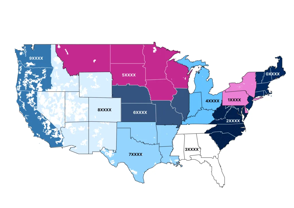
In 2025, the USPS implemented ZIP+4, adding four digits to identify specific street segments or high-volume recipients. This enhancement delivers particularly valuable precision in urban settings where a single ZIP code might cover thousands of delivery points.

The American system illustrates the essential balance in postal coding: sufficient granularity for accurate delivery while being simple for public adoption. While the U.S. achieves this purely numerically, international systems often have different structures and features to address similar fundamental challenges.
Postal Codes Around the World
Let’s explore how different regions have developed their unique postal systems, from Europe’s alphanumeric innovations to Africa’s emerging infrastructures. Each system reflects local geographical and administrative needs.
European Postal Systems: Alphanumeric Innovation
European countries have the most complicated postal code structures worldwide, frequently combining letters and numbers for exceptional precision.
Germany’s five-digit Postleitzahl (PLZ) similarly divides the country into regions and districts, evolving significantly after reunification in120262

The Netherlands implements a four-digit plus two-letter format (1234 AB) covering about 25 houses per code.

France employs a five-digit numeric system (code postal) with the first two digits corresponding to départements.

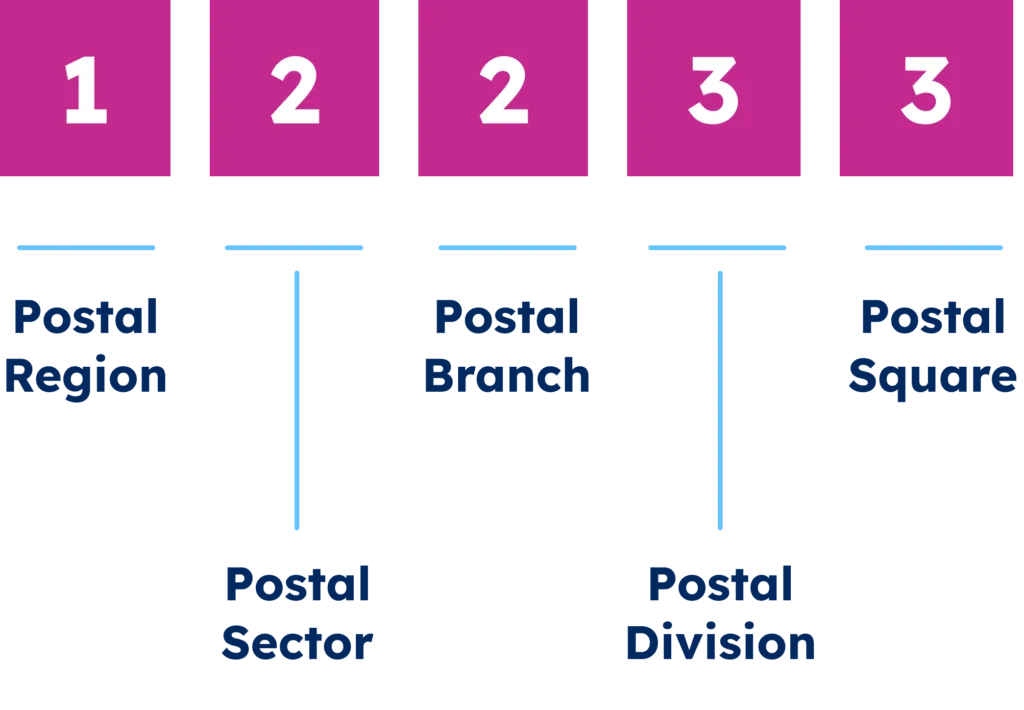
The United Kingdom’s advanced postal code system, developed in the 1960s, uses a two-part format: an outward code (“SW1A”) indicating the postal district and an inward code (“1AA”) identifying specific streets or properties.

These European systems reflect each nation’s administrative structure, population density, and historical development—creating tailored mechanisms for efficient mail delivery.
Asian Postal Systems: Diverse Approaches to Complex Territories
Asia presents some of the most fascinating postal code implementations, addressing challenges like dense urban centers, complex writing systems, and rapid economic development.
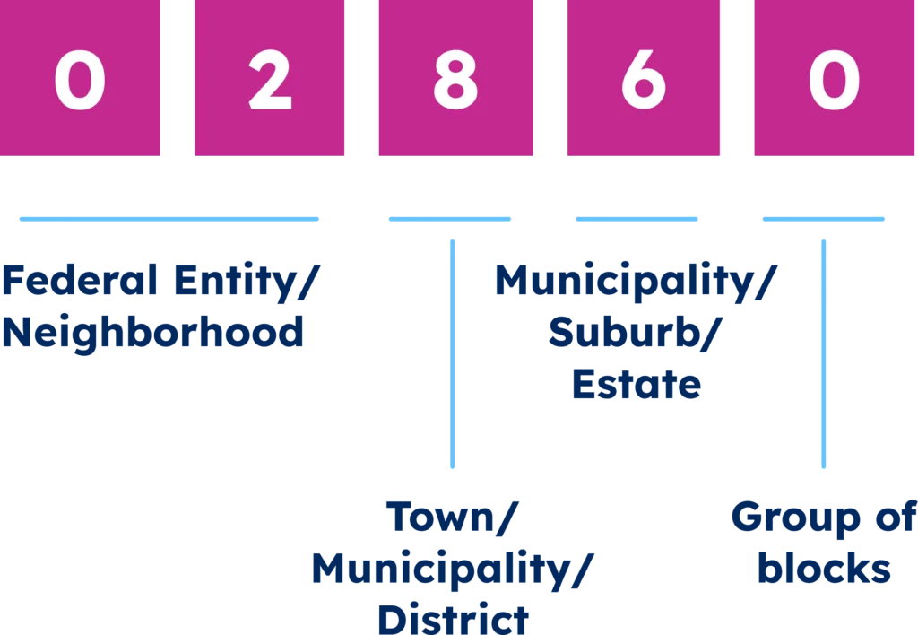
Despite its vast territory and enormous population, China recently implemented its postal code system. Chinese postal codes consist of six digits, with the first two representing the province or municipality, the middle two indicating the prefecture or city, and the final two specifying a delivery zone.

Japan’s postal code system (郵便番号, Yūbin Bangō) consists of seven digits formatted as three digits, a hyphen, and four digits (e.g., 123-4567). The first three digits identify the region and city, while the last four specify districts or blocks.
This highly structured approach helps navigate Japan’s dense urban environments where addressing can be particularly challenging due to the non-sequential nature of many Japanese addressing schemes.

India employs a six-digit Postal Index Number (PIN) code, where the first digit represents one of the nine postal zones, and subsequent digits narrow down to the sorting district and delivery post office.

The diversity of Asian postal systems reflects varying stages of economic development, historical trajectories, and cultural approaches to address. In many Asian countries, rapid urbanization and economic growth have required multiple revisions of postal systems in recent decades, demonstrating how postal codes evolve alongside the societies they serve.
North and South American Systems: Regional Variations
Beyond the United States, the Americas feature diverse postal code implementations reflecting each country’s geographic characteristics, administrative structure, and historical evolution.
Canada employs a six-character alphanumeric system (A1A 1A1) called the Postal Code. The first three characters (Forward Sortation Area) designate geographical regions within cities or rural areas, while the final three (Local Delivery Unit) identify specific neighborhoods or high-volume recipients.

Mexico uses a five-digit numeric Código Postal with the first two digits corresponding to its 32 states, creating direct alignment between administrative and postal boundaries.
Brazil implements an eight-digit CEP (Código de Endereçamento Postal) formatted as five digits, a hyphen, and three more digits, enabling navigating complex urban environments and extensive rural regions.

Other South American nations generally utilize numeric systems with varying precision levels. These diverse approaches demonstrate how countries adapt universal sorting principles to their specific geographic and demographic contexts, balancing technical efficiency with practical usability.
Africa and the Middle East: Emerging and Evolving Systems
Africa and the Middle East have varied addressing landscapes, with significant contrasts in postal code implementation and sophistication.
South Africa utilizes a straightforward four-digit numeric code identifying specific delivery offices.

Egypt employs a five-digit system with the initial digit designating the governorate.

Saudi Arabia uses a five-digit numeric code, providing precise geographic sorting information.
However, numerous African nations continue to operate without formal postal codes, relying on post office boxes, city names, and regional indicators for mail sorting.
While countries like Ghana, Ethiopia, and Kenya are working to expand postal code coverage, implementation faces substantial challenges related to infrastructure limitations, rural addressing complexities, and public adoption barriers.
These regional variations illustrate how postal systems develop along a continuum. Implementation typically reflects a country’s infrastructure development, urbanization patterns, and economic priorities.
Understanding Structural Differences in Global Postal Codes
Different countries approach postal codes with varying formats and organizational principles. Let’s examine the key structural differences that impact how these systems function across borders.
Numeric vs. Alphanumeric Systems
| Category | Numeric Systems | Alphanumeric Systems |
|---|---|---|
| Format | Digits only | Letters + numbers |
| Examples | US, France, Japan | UK, Canada, Netherlands |
| Length | 4–7 digits | Variable |
| Precision | Needs more digits for precision | High precision with fewer characters |
| Compatibility | Works well with numeric systems | May face compatibility issues and integration challenges in numeric-only systems |
A foundational distinction exists in global postal systems’ elemental character composition: purely numeric versus alphanumeric formats.
Numeric systems (US, France, Japan) use only digits (4-7 numbers), offering simplicity and keypad compatibility but requiring more digits for precision.
Alphanumeric systems (UK, Canada, Netherlands) combine letters and numbers, creating compact codes with greater information density.
Despite containing just six characters, the UK’s “SW1A 1AA” format can pinpoint areas as precise as specific buildings or small address clusters. They offer superior precision with fewer characters, though they may cause compatibility issues in systems optimized for numeric-only data.
The implementation choice typically reflects population density, postal history, administrative boundaries, addressing conventions, and usability. For international businesses, this distinction requires validation processes that accommodate both formats.
Hierarchical vs. Non-hierarchical Structures
| Category | Hierarchical Systems | Non-Hierarchical Systems |
|---|---|---|
| Structure | Codes reflect geographic levels | No spatial order in codes |
| Examples | US, Germany, China | Small island nations (example: Nauru and Tuvalu), Hong Kong, Andorra |
| Logic | Nested, progressive digits, and operational | Operational over geographic logic |
| Benefits | Enables spatial grouping and prioritizes delivery efficiency | Very limited, as they are virtually not in use around the world |
| Challenges | Needs country-specific knowledge | Needs country-specific knowledge Harder to infer location |
| Use Cases | Clustering, segmentation, logistics | Purely routing-focused tasks |
A critical structural distinction in postal code systems involves hierarchical versus non-hierarchical geographic organization.
Hierarchical postal systems (US, Germany, China) embed geographic relationships in code structure. For example, U.S. ZIP codes identify regions with the first digit, then narrow them down to specific areas.
Non-hierarchical systems assign codes without geographic progression, prioritizing operational efficiency.
A country’s approach impacts business applications like clustering, territory management, logistics, and market segmentation. While hierarchical systems enable geographic inference, implementation requires knowledge of each country’s specific structure.
Precision and Coverage Variations
| Category | High-Precision Systems | Low-Precision Systems |
|---|---|---|
| Precision | Identifies buildings or small clusters | Covers large areas, e.g., towns |
| Examples | UK, Netherlands | Italy, Brazil, Hungary, Poland, Russia, Sweden, Guatemala, South Africa |
| Coverage | Nationwide, complete | Urban-focused or post office-based |
| Use Cases | Accurate delivery, service area mapping | Broad delivery zones |
| Business Impact | Supports detailed analysis and routing | May reduce accuracy |
| Implementation Tip | Tailor by country for reliable data use | Combine with other data when needed |
Global postal systems vary greatly in precision and coverage.
High-precision systems (UK, Netherlands) can identify specific buildings, while lower-precision ones may cover entire towns.
Coverage completeness differs too – some countries maintain comprehensive coding nationwide, while others focus on urban centers or use post office boxes instead of geographic zones.
These differences affect business functions like address verification, delivery estimates, service areas, and market analysis.
International organizations must understand each country’s precision characteristics, as location references that work in one market may be inadequate in another.
Challenges of Global Postal Systems that Companies Will Face
Postal codes are essential for global operations, but inconsistencies across countries create significant challenges. Here’s a breakdown of the most common hurdles.
Finding Reliable Data Sources
Reliable postal data isn’t always easy to find. Many companies struggle with unofficial sources, which often lead to misdeliveries and failed address validations. Staying up to date is also tough, as postal codes change regularly, and announcements aren’t always timely.
On top of that, technical accuracy matters. Coordinates and postal code attributes need to be correct to avoid errors in mapping and logistics. Finally, if the data model is unclear or poorly documented, integration becomes time-consuming and error-prone.
Designing a Unified Data Model
Building a single data model that works for every country is tricky. Postal codes come in many formats, some numeric and some alphanumeric, and the field requirements vary widely.
To solve this, companies must design a consistent structure that adapts to each country’s constraints. That includes supporting different character sets, linking codes to administrative areas, and applying validation rules that align with local norms. E-commerce companies often tackle this with flexible systems built to adapt globally.
Pre-processing and Extracting Information
Address formats differ drastically between countries, making standardization a challenge. This forces companies to create custom systems for parsing and processing addresses.
Advanced parsing tools must detect postal code placement within an address, extract the right elements regardless of order, and normalize the data. It’s also crucial to recognize local abbreviations and terminology. Global shipping companies typically rely on country-specific rules to handle this effectively.
Linking to Administrative Divisions
Linking postal codes to administrative areas is essential for tax reporting, compliance, and analytics, but it’s rarely straightforward. In many countries, postal boundaries don’t align with administrative ones.
Companies often deal with overlapping regions, inconsistent administrative levels, and outdated maps. Some areas have multiple names for the same region, which adds to the confusion. To manage this, businesses usually combine several data sources and build custom tables for each country.
Geocoding Postal Data
Converting postal codes into geographic coordinates varies in difficulty by region. In some areas, postal codes are precise; in others, they’re vague and cover large areas.
Businesses often need to apply different geocoding strategies depending on the country. Some regions use postal centroids, while others require full addresses. Confidence scoring and fallback methods help handle areas with sparse postal coverage. Companies like ride-sharing apps rely on these strategies to improve accuracy and timing.
Linking Different Location Standards
Many industries require connections between postal codes and other location standards, such as ISO3166-2, NUTS, FIPS, or UN/LOCODEs. Creating these links can be difficult due to formatting differences, language barriers, and mismatched update cycles.
Standards also vary in granularity, which complicates integration. For example, financial institutions often need to report activities by region and maintain complex matching systems to meet regulatory requirements.
Maintaining Data Quality and Consistency
Postal systems constantly evolve. New codes are introduced, boundaries shift, and administrative regions are reorganized. Some countries have even overhauled their entire system, like South Korea in120262
To stay accurate, companies need regular updates from official sources, country-specific validation rules, and quality checks that ensure geographic consistency. Many global businesses update their databases weekly, with emergency updates when major changes occur.
Critical Business Impacts of These Challenges
These postal system issues impact key business areas.
Failed address validations frustrate customers and increase cart abandonment. Inaccurate postal data disrupts deliveries. Poor data also creates compliance risks for industries like finance and healthcare. On top of that, market analysis becomes unreliable when postal precision varies across regions.
How Companies Overcome These Challenges
Despite the complexity, businesses have developed practical solutions to navigate global postal challenges.
Maintaining Comprehensive Postal Code Data
Managing global postal code data requires constant updates and high-quality sources. Companies must track changes, validate entries against local formats, and maintain historical versions of data.
Fallback systems are also important, especially in countries with limited postal infrastructure. Many organizations work with location data providers to ensure accuracy and reduce costs.
Implementing Flexible Address Validation
Address validation systems must adapt to each country’s specific format and conventions. Generic validation often fails when faced with unique field requirements or non-Latin characters.
Best-in-class systems use localized rules, adaptive input fields, and regional formatting to handle exceptions smoothly. This approach improves data quality, boosts customer experience, and supports successful deliveries.
Building Location Intelligence Beyond Postal Codes
While postal codes provide a foundation, companies benefit from combining them with additional data, such as administrative divisions, transportation networks, and demographics.
This multi-layered location intelligence offsets the limitations of postal codes and provides deeper insight for planning, analytics, and decision-making.
Strategic Global Postal Intelligence for Business Success
Solving postal data challenges unlocks growth opportunities for international companies.
Logistics and Supply Chain Optimization
Postal codes are central to logistics, helping companies plan delivery routes, estimate times, and design distribution networks. But variations in postal precision, rural coverage gaps, and local delivery laws complicate things.
To overcome this, logistics systems integrate postal intelligence with local delivery patterns and exact geographic coordinates.
Geocoding and Spatial Analysis
Turning postal codes into coordinates enables spatial analysis, but accuracy varies by country. Some regions require centroid-based approaches, while others demand exact point data or boundary polygons.
A tailored approach using multiple datasets and geocoding methods helps businesses maintain consistent analysis across all markets.
Market Analysis and Territory Management
Postal codes serve as building blocks for market analysis and territory planning. In some countries, like Germany and Japan, codes align well with administrative areas. In others, they follow operational logic and vary widely in size.
Companies can adapt by building local hierarchies, normalizing precision levels, and supplementing postal data with other geographic info. Custom territories that reflect local realities ensure accurate, actionable insights.
Conclusion
Navigating global postal systems is complex, but mastering them brings real opportunities and benefits for cross-border organizations. From accurate address handling and smoother deliveries to sharper location analysis and better regulatory compliance, precise postal data gives international businesses a competitive edge.
At GeoPostcodes, we’ve built the most complete postal code database covering 247 countries, offering postal codes, cities, boundaries, and demographics for reliable location intelligence.
Whether validating international addresses, implementing location services, analyzing markets, or optimizing logistics networks, accurate postal data provides essential geographic context for success in today’s global marketplace.
We invite you to browse our data for free and download a free sample here. Feel free to discover how precise location intelligence can transform your international operations and request a quote.
FAQ
Do ZIP codes exist in other countries?
While most countries have postal code systems, the term “ZIP code” is specific to the United States. Other nations use various formats and terminology such as postcodes (UK), codes postaux (France), or PLZ (Germany).
Which country has no ZIP code?
Approximately 40 nations operate without formal postal codes, including Hong Kong, Bahamas, Angola, Belize, and several smaller island nations where mail delivery relies on alternative addressing systems and post office boxes.
Do other countries use ZIP codes like the U.S.?
Yes, but many use different formats. Canada, for example, has an alphanumeric postal code system. In various countries, the post office system assigns post codes, which postal workers use for sorting and deliveries via the local post office.
Are ZIP codes an American thing?
Yes, “ZIP” (Zone Improvement Plan) is exclusively American terminology. While most countries utilize postal code systems, they employ different names, formats, and structures adapted to their specific geographic and administrative needs.
Is ZIP code 11111 valid?
No, 11111 is not a valid USPS ZIP code. The lowest assigned U.S. ZIP code is 00501 (Holtsville, NY), and no ZIP codes beginning with “1” start with consecutive identical digits.
How do Canadian postal codes differ from ZIP codes?
Canadian postal codes follow an alphanumeric postal code system (e.g., K1A 0B1), unlike numeric U.S. ZIP codes. The post office system assigns them based on geography, helping postal workers at the local post office efficiently sort and deliver mail.
What countries use postal codes?
Most countries have postal code systems.
GeoPostcodes’ world postal code database covers postal codes from countries globally.
How do I validate non-US postal codes?
Use GeoPostcodes’ international address validation service for postal codes from any country.
Where can I find a list of addresses with postal codes?
GeoPostcodes provides a master address list with postal codes, particularly comprehensive for the US.


