
An address is the most common form of spatial identification and, in conjunction with the postal code, serves as the backbone of most postal and delivery systems worldwide. However, unlike geographic coordinate systems, addresses do not follow a global standard and can experience significant variation across regions, as we have explored in our article dedicated to international addresses.
In consequence, it is common for government agencies and local administrations to design different encoding and normalization standards when storing, cataloging, and distributing address data.
Next, we will describe in detail the street nomenclature and address system of the South American country of Colombia, as its particularities highlight the complexities that sourcing and aggregating global street data can entail.
💡 For over 15 years, we have created the most comprehensive worldwide zip code database. Our location data is updated weekly, relying on more than 1,500 sources. Browse GeoPostcodes datasets and download a free sample here.
Street address basics
Let’s start with a brief introduction to street nomenclature. It defines how streets are named and organized and makes one of the most basic elements of an address. There can be significant regional variation in how streets are named and organized, but street names generally have two elements: a generic street type and a specific name.
The generic street type determines the category a street belongs to: avenues, alleyways, streets, and passageways. Local conventions when assigning the street types exist, especially in grid-based cities. For example, in Washington DC (USA), avenues are diagonal roads intersecting the grid of regular “streets”. In many European cities, avenues are a city’s larger principal roads.
The name may be thematic, numeric, or a combination of both. Thematic names may reflect historical figures, events, places, or geographical descriptors. Numeric names are more common in grid-based cities. A cardinal direction or other distinction may be added when numbers are repeated.
The combination of these components, alongside a postal code in the countries that have implemented it, makes an identification unique to the city or district and what we normally know as an address.
There is one component missing: the building number. They are used for the individual identification of properties. Commonly, properties are identified by numbers assigned in an increasing sequence following the street direction, with odd and even numbers distributed alongside each side. Yet this can also present regional variations, as we are about to see with the specific case of Colombia.
A bit of history
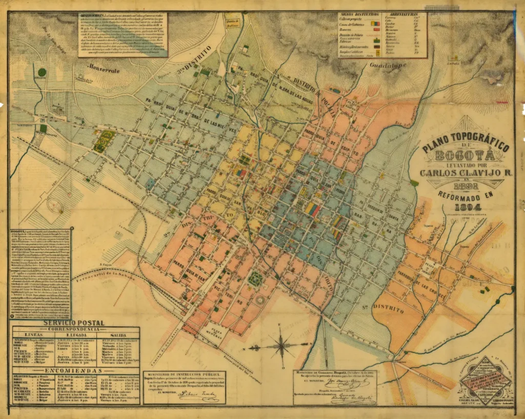
Like many neighbors, Colombia inherited a grid-based urban plan from Spanish colonial times. This form of urban organization involved cities designed as parallel and perpendicular streets built around a main square containing the principal buildings for the political and religious administration.
While streets were thematically named, by the end of the 19th century, local urban planners from Bogotá started designing a new system that could better fit the realities of the city. After some failed attempts, a new system was successfully implemented; streets were numbered sequentially from the city’s central square outwards.
The system was first applied to the capital city of Bogotá and then expanded to the entire country.
The Colombia address format system
Colombia uses a street nomenclature system based on numbered streets expanding outwards from a central point. Street types are assigned based on their direction:
CALLE → Streets running East-West
CARRERA → Streets running North-South
DIAGONAL → Streets running diagonally Northeast-Southwest
TRANSVERSAL → Streets running diagonally Northwest-Southeast
Additionally, main streets may be given the additional name of avenida or avenue, making it possible for a street to have any of the aforementioned types plus the avenida designation. Thus, a city’s central point will be marked by the intersection of Calle 1 and Carrera 1, and every following street will continue sequentially from this point, using cardinal designators to differentiate each side.
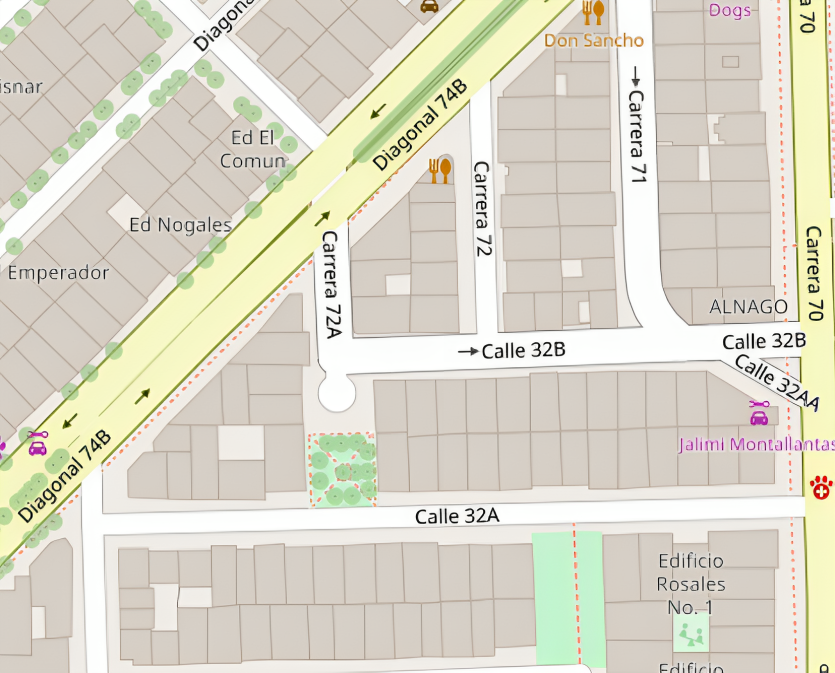
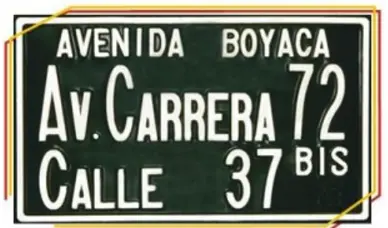
Each block is further delimited using the concept of primary and reference streets, a key component of any address in Colombia. The primary street is where the property is located. In contrast, the reference street is the street of a lower denomination that intersects the primary street on either end of the block. As a practical example, the block of Carrera 72 (the 72nd street running north to south) intersected by Calle 37 and Calle 38 will be named “Carrera 72 – 37”.
This means any address containing the “Carrera 72 – 37”, often styled as “Carrera 72 # 37,” will be in that street block. Both primary and reference streets are often present on street plaques, as seen below.
primary and reference streets.
Why are reference streets important, and why are they included on street plaques? As we will see, they are crucial to build a complete address. Property numbers in most Colombian cities do not follow an arithmetic sequence but instead reflect the distance, in meters, from the intersection of primary and reference streets.
This means addresses take the “Primary street # Reference street – Distance” format, which allows visitors, delivery, and emergency services to quickly find any given property from the starting point of the intersection. Let us see some examples:
Calle 122 # 18 – 15 → 122nd street, 15 metres from the intersection with 18th street
Carrera 82 # 25B – 10 → 82nd street, 10 meters from the intersection with 25B street
When the primary street is a dead-end or is only intersected by one other street, that one will be the reference street regardless of the denomination.
The house number plaque above a property door will reflect this information.

Knowing the distance in meters from the intersecting streets provides some level of reference as to how far into the block one must move to find the property. While this is not too unlike traditional sequential numbering, the inclusion of reference streets allows to pinpoint street blocks and thus quickly delimit the approximate location of a property.
Variations of this system exist throughout the region. For instance, addresses in Cuba and the Costa Rican capital of San José often include a primary street and two reference streets, the intersecting streets at both ends.
Processing address data
Understanding the regional variation in address formats is not the only challenge when working with international address data. Government agencies often employ different strategies when collecting, storing, and distributing spatial data. While the elements of an address can be standardized – as we have seen above – it is often the case that they will be written slightly differently, with variation in cases, in the order of words or terms, etc. In such cases, it is common for addresses to be encoded into normalized strings following a more rigid format.
The Colombian National Institute of Statistics has implemented a normalization system for their address data, as shown below.
Avenida Carrera 73B Sur # 4 – 10 Torre 2 → AV KR S 073 B 04 10 TO 02
Calle 78 Sur # 20D – 15 → CL 078 S 020 D 015
The addresses are transformed into standardized strings following rules set by the national statistics authority. When processing address data, they must first be “decoded” back into more readable strings.
Conclusion
International address data can come in many different shapes and sizes, and it is fair to say it can be as diverse as our different societies are. Processing diverse data requires developing a good understanding of its distinctive particularities, some of which may be intrinsically linked to the cultural and social realities of the place where the data is collected. As we have seen, processing challenges can compound as we also encounter different encoding and normalization rules the data collectors apply.
In this article, we have taken a general overview of the characteristics that make addresses in Colombia distinctive. However, the data processing journey does not end there; this is one case of many. We invite you to look at our blog article exploring different formats worldwide if you have not already.
If you are interested on obtaining Colombia’s address data for your enterprise location data management, ERP & TMS practices or geomarketing don’t hesitate to contact us.
What does a Colombian postal code look like?
A Colombian postal code typically consists of six digits, which are used to identify specific regions and areas within the country. It follows the format of “999999,” with each digit serving a distinct purpose in the geographic hierarchy, enabling efficient mail delivery. For more details about zip code data for Colombia, visit our website.
Does Colombia have zip code?
Colombia uses a unique six-digit postal code system called “Código Postal.” These Colombian postal codes serve the same purpose as ZIP codes in the United States, helping to pinpoint specific locations for mail delivery and geographic referencing.
What is the mail system in Colombia?
The mail system in Colombia is managed by the government-owned organization 4-72. This postal service provides mail and package delivery throughout the country, domestically and internationally. It operates an extensive network of post offices, mailboxes, and courier services, facilitating reliable and efficient mail and package handling for residents and businesses in Colombia.