
Have you ever wondered how shipping companies get your cargo to the right port out of thousands worldwide? They rely on a simple but powerful system: a five-character code that keeps global trade running smoothly.
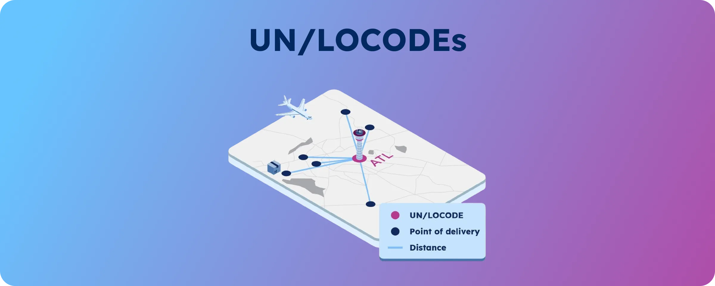
These are called UN/LOCODEs (United Nations Code for Trade and Transport Locations). Each one is a short geocode that pinpoints a transport hub. Think of them like postal codes—but for cargo. Instead of guiding mail to your doorstep, they direct ships, planes, and trucks to the right terminals around the globe.
Understanding the UN/LOCODE Structure
Each UN/LOCODE uses a simple format that works across language barriers. The code breaks down into two distinct parts that pinpoint exact locations.
The first two characters represent the ISO country code, immediately telling you which nation the location belongs to. The remaining three characters identify the specific location within that country. For example, “US LAX” points to Los Angeles in the United States, while “CN SHA” identifies Shanghai in China.
Key Concept. UN/LOCODEs remove confusion by offering a universal reference system. They work no matter the local language or place name variations.
This standardization proves invaluable when dealing with international partners who might know the exact location by different names. Whether you call it “Milano” or “Milan,” the UN/LOCODE “IT MIL” leaves no room for misunderstanding.
The codes also specify the type of transportation hub each location represents. You’ll know if it’s a port, airport, road terminal, rail stop, or another type of hub. This helps you plan better routes and pick the right transport for your cargo.

Why UN/LOCODEs Matter for Your Business
UN/LOCODEs are essential communication tools that streamline your logistics operations. When you ship goods across countries, these codes help everyone involved understand each other across languages.
Your shipping documentation becomes more accurate, and processing gets faster when you use UN/LOCODEs. Clear, precise location data improves bills of lading, commercial invoices, and customs forms. You spend less time clarifying destinations and more time moving products.
Think about it: How much time does your team spend clearing up shipping destinations with international partners?
The codes also boost your data analysis. You can track cargo movements with greater precision. For sustainability reports, you can track port performance, compare regions, and measure transport emissions. This data-driven view helps you improve your network and find ways to cut costs.
Customer satisfaction rises when deliveries arrive where they should, on time. UN/LOCODEs lower the risk of misrouted cargo. That means fewer delays—and happier customers.
Real-World Applications in Global Logistics
UN/LOCODEs prove their worth across various aspects of international business operations. Their versatility makes them valuable tools for companies of all sizes engaged in global trade.
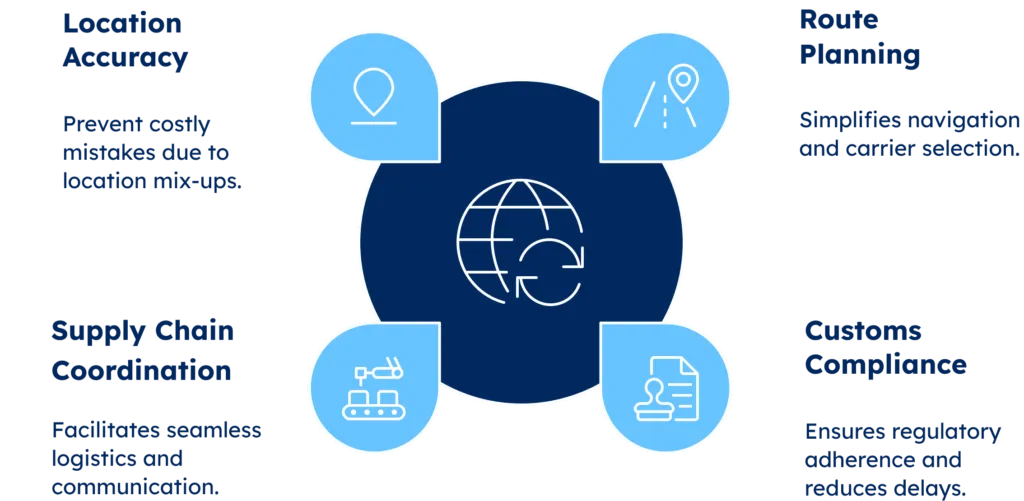
Route Planning and Carrier Selection become easier when you can name exact transport hubs. Instead of writing lengthy descriptions, you enter the UN/LOCODE for your starting point and destination. This accuracy helps carriers give better quotes and set realistic delivery times.
Customs and Regulatory Compliance also improves with UN/LOCODEs. Customs officials use the codes to check where goods come from and where they’re going. That speeds up clearance and reduces delays. When your paperwork includes the correct codes, you avoid many common issues.
Supply Chain Coordination gets smoother when everyone uses the same codes. Freight forwarders, shipping lines, and logistics teams work better using the same codes.
Important Note: UN/LOCODEs are vital for businesses across time zones and languages. They prevent costly mistakes caused by location mix-ups.
Success Story: How MSC Transformed Its Operations
MSC Company struggled to manage location data across its 675 offices in 155 countries. Even minor errors led to significant issues with bookings and shipping documents.
MSC achieved remarkable operational improvements by implementing enriched UN/LOCODE data from GeoPostcodes. They eliminated repetitive data processing days, saving approximately €500,000 annually. The company handled over 3,000 global locations each year. It also made it easier to open and close Inland Container Depots.
The results extended beyond cost savings. MSC reduced financial penalties, minimized business disruptions, and improved service quality. These changes helped retain more customers and drive revenue growth across global operations.
Understanding the Limitations
While UN/LOCODEs offer useful standardization, they have limits that global businesses should know. Understanding these limits helps you plan better and add support where needed.
Coverage Inconsistencies Across Countries
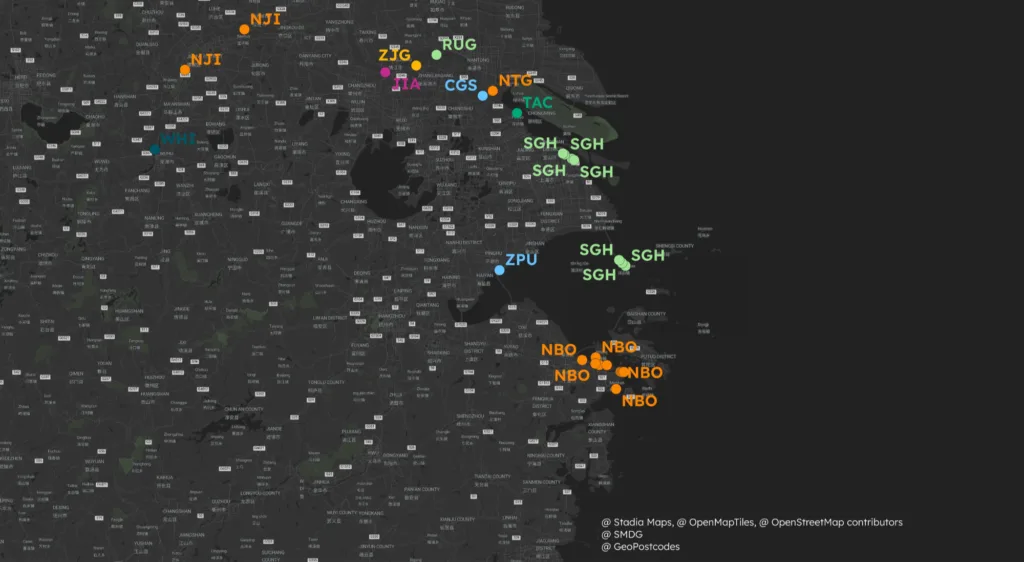
UN/LOCODE coverage varies significantly between nations, creating challenges for comprehensive global operations. Major trading countries—like the United States, China, and many in Europe—often have strong UN/LOCODE coverage. This reflects their global economic importance.
Smaller economies and developing nations may have limited coverage, even with many active trade hubs. You might need extra location identifiers to fill the gaps in these regions.
Consider This: Before entering a new market, check UN/LOCODE coverage for that region. This helps you spot missing codes and prepare with alternative references.
One Code, Multiple Facilities Challenge
The UN/LOCODE system often uses a single code for areas with multiple transport sites spread across a wide area. This “one location, one code” approach creates precision challenges for detailed logistics planning.
Los Angeles provides a perfect example of this limitation. The city ranks among the world’s top 15 for passenger airports, freight airports, and container seaports. Yet the Port of Los Angeles and LAX Airport sit approximately 25 kilometers apart – about a 30-minute drive – while sharing the single UN/LOCODE “US LAX.”
Major Global Examples:
- Rotterdam (NL RTM): Europe’s largest seaport spans over 40 kilometers with multiple terminals up to 20 kilometers apart
- Singapore (SG SIN): Operates terminals across the city with facilities up to 15 kilometers apart
- Hamburg (DE HAM): Features specialized terminals spread across both sides of the Elbe River
This lack of detail causes problems when you need to name exact pickup or delivery points in large ports. Your drivers might receive directions to “Rotterdam” when they need to reach a specific terminal 40 kilometers away.
Data Quality Concerns
The UN/LOCODE database has quality issues that can hurt logistics reliability. Understanding these issues helps you implement appropriate verification procedures.
Common Data Quality Issues include inconsistent formatting with empty strings and unexpected spaces, gradual data degradation over time, including incorrect location names, implementation gaps where marked-for-removal locations remain in the database, and errors in critical reference codes, like IATA airport codes.
Some entries list fake IATA codes. Others have missing or wrong coordinates. These issues severely limit the system’s usefulness for route planning and distance calculations.
The following image summarises the common issues with data quality.

Remember: Check critical UN/LOCODE details using more than one source, especially for new or unfamiliar places.
The Advantages That Drive Adoption
Despite some limits, UN/LOCODEs offer clear benefits. That’s why they’re used widely in global logistics. These advantages often outweigh the system’s constraints for most international business applications.
Official UN Governance and Stability
The United Nations Economic Commission for Europe (UNECE) runs the UN/LOCODE system. This gives the system legitimacy and stability that businesses can trust. Official oversight keeps the codes consistent and free from political or commercial bias.
You can use UN/LOCODEs across your global operations with confidence. The system has strong institutional support and won’t disappear overnight. That stability matters when you plan long-term logistics or launch new transport systems.
Comprehensive Global Coverage
UN/LOCODEs cover locations on every continent and in nearly every country involved in global trade. This broad reach lets you standardize location data across your whole operation. You don’t need separate systems for different regions.
This global coverage is a big win for multinational companies. It helps you keep data consistent across markets. You can train staff on one system that works everywhere, cutting down on confusion and training costs.
Rich Feature Integration
UN/LOCODEs include valuable features beyond basic location identification. The codes show facility types—like ports, airports, road terminals, and rail terminals. They also include status: active, under development, or discontinued. Many entries link to related standards, such as IATA airport codes.
This rich data makes it easier to connect different logistics systems. Your transport software can use UN/LOCODEs to check facility types and status automatically.
Application: Use UN/LOCODE data to automate carrier selection and route planning in your logistics systems.
Industry-Wide Standard Adoption
The most practical advantage lies in widespread industry acceptance. UN/LOCODEs are used in shipping papers, customs forms, transport tools, and logistics databases worldwide.
This global use means you can speak the same language with partners, carriers, and regulators. You don’t need different location systems. Suppliers in Asia, teams in Europe, and customers in the Americas all use the same codes.
How GeoPostcodes Enhances UN/LOCODE Data
GeoPostcodes addresses many UN/LOCODE limitations through sophisticated data enhancement and integration processes. Their approach turns the basic UN/LOCODE system into a stronger, more accurate way to reference locations.
Comprehensive Postal Code Integration
GeoPostcodes links UN/LOCODEs to postal codes and localities. This creates smooth connections between transport codes and detailed postal systems. With this setup, you can switch between location reference systems used across your operations.
The structure goes from countries down to streets and postal codes. It gives you the detail that UN/LOCODEs alone don’t provide. You can now bridge the gap between shipping destinations and final delivery addresses.
Data Quality Corrections and Validation
GeoPostcodes fixes UN/LOCODE data issues by checking, cleaning, and aligning the information. They ensure 99.6% of postal codes have accurate coordinates. The remaining 0.4% get their coordinates from larger administrative areas.
They also correct country codes, coordinates, and IATA codes to fix errors in the original database. This added accuracy helps with route planning and distance tracking in your logistics.
Key Concept: Better data means fewer shipping errors and more reliable automated systems.
Port Terminal Granularity
GeoPostcodes solves the “one code, multiple facilities” issue by linking UN/LOCODEs to detailed port terminal data. Their Global Logistics Data Suite shows exact shipping hub details. This helps cargo reach the right drop-off point in large ports.
This upgrade is key for maritime logistics. Major ports like Rotterdam or Singapore cover huge areas and have many specialized terminals. With this data, you can name the exact terminal in a port. That cuts down on confusion and avoids delivery delays.
Complete IATA Code Marking
GeoPostcodes uses a consistent format for all IATA codes. This makes it easy to spot locations with airport facilities. It also fixes errors in how the original UN/LOCODE database handles aviation data.
This reliable IATA link keeps your records in line with aviation standards. It also helps you coordinate air and sea cargo with fewer issues.
Making UN/LOCODEs Work for Your Business
Knowing how UN/LOCODEs work helps you make better logistics decisions. It also boosts efficiency in your operations. To get the most value, understand both the system’s strengths and its limits. Then, apply the right solutions.
Start by auditing your current location referencing practices across different departments and regions. Identify where standardization could reduce errors and improve communication with international partners. Consider how enhanced UN/LOCODE data could address specific challenges in your logistics network.
Which parts of your logistics would improve with more detailed location codes?
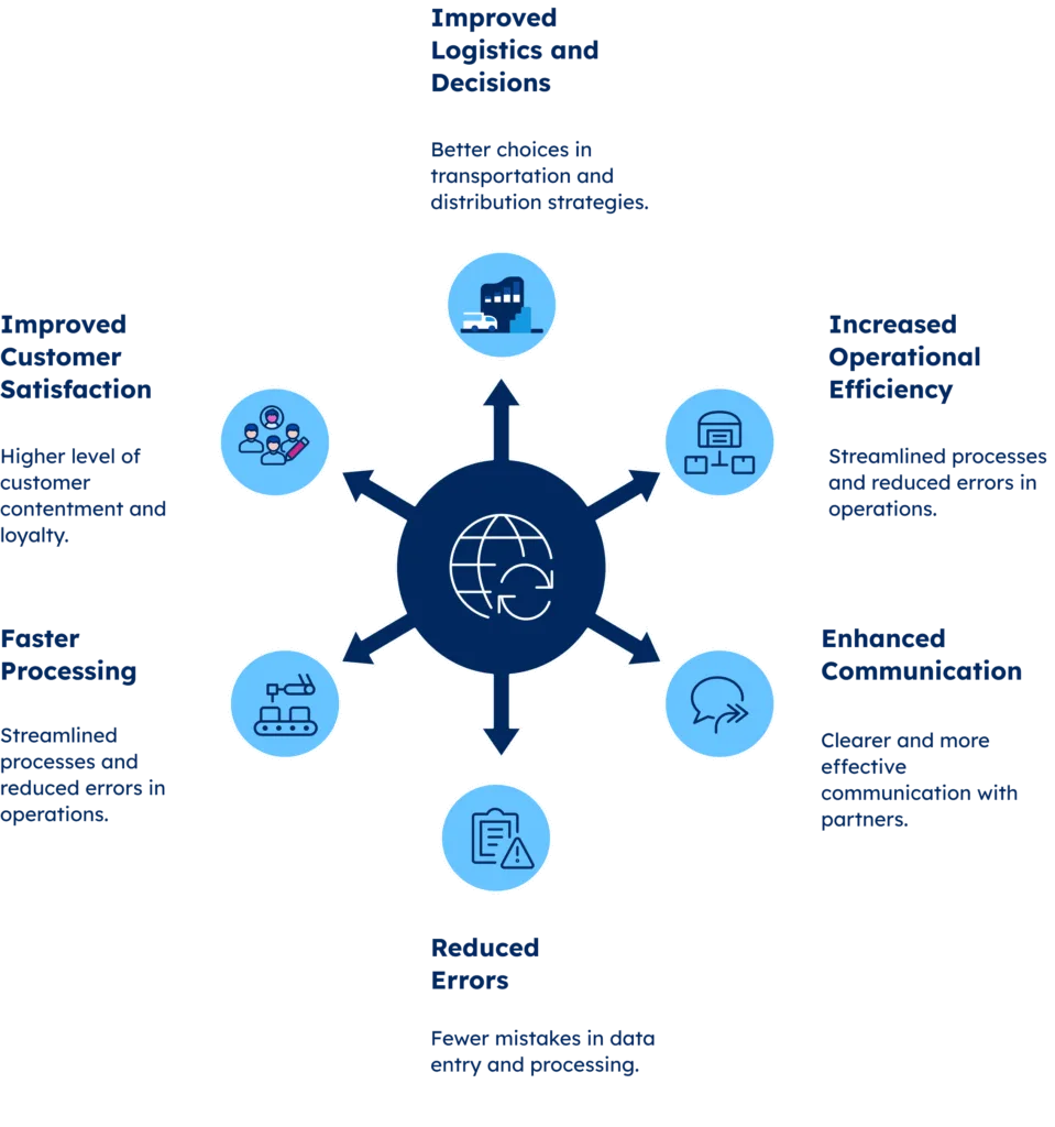
For global businesses, investing in enhanced UN/LOCODE data brings clear returns. You reduce errors, speed up processing, and improve customer satisfaction. Standard codes and detailed location data create a solid base for smooth global operations.
This look at UN/LOCODEs shows how standardized location data affects every part of global logistics. These five-character codes help with everything—from identifying cargo to managing supply chains. They are essential tools in international trade. Yes, the system has limits, but improved versions solve those while keeping the global advantages that make UN/LOCODEs so valuable.
As global trade grows more complex, accurate and complete location data becomes essential. Companies that invest in better location intelligence now will be ready for the challenges of tomorrow’s market.
Conclusion: Streamline Your Global Operations with Enhanced Location Intelligence
In this overview of UN/LOCODEs, we’ve seen how these five-character codes form the backbone of international logistics. They support global coordination but also come with limits in coverage and detail.
The standardized system allows smooth communication across supply chains. Still, large-scale operations need more precise tools. Basic UN/LOCODEs often fall short in large port complexes and contain data quality issues.
Managing these challenges takes time and expertise, resources that many companies lack. Enhanced UN/LOCODE systems fill that gap. They link to postal codes, fix data errors, and add terminal-level detail. This extra precision delivers real value for companies that rely on accurate logistics data.
For over a decade, we’ve offered advanced location intelligence to global businesses. We turn UN/LOCODE limits into strategic advantages. Browse our data for free to see how better location info clears up confusion and strengthens your global operations. Contact us.

