
Key takeaways
- ZIP codes prioritize mail delivery efficiency over administrative boundaries, sometimes crossing state lines.
- Cross-state ZIP codes create challenges for business analysis, taxation, and regulatory compliance.
- Different countries handle postal-administrative boundary alignment with varying approaches and precision.
- Advanced location data with boundary mapping solves cross-border ZIP code identification problems.
Introduction
Businesses planning expansion strategies, analyzing customer demographics, or creating delivery zones often rely on ZIP codes as geographical units. However, behind these seemingly simple combinations of numbers and letters lies a complex system that doesn’t always align with political boundaries. When companies use location data, they often ask: do ZIP codes cross state lines?
The answer might be surprising: ZIP codes don’t always follow administrative boundaries. They focus on making mail delivery efficient, not on fitting state borders.
The gap between postal and administrative geography can lead to both challenges and opportunities for businesses. This is especially true for those operating globally or looking to expand into new areas.
Grasping ZIP code boundaries is key for accurate market analysis, compliance with state regulations, and efficient logistics planning. Understanding different postal systems around the world is vital for businesses that operate globally.
This article explores the complex relationship between ZIP codes and state boundaries. It discusses the impact on businesses and how good data helps companies make smarter choices.
💡 For over 15 years, we have created the most comprehensive worldwide ZIP code and boundary databases. Our location data is updated weekly, relying on more than 1,500 sources. Browse GeoPostcodes datasets and download a free sample here.
The Fundamental Purpose of ZIP Codes: Beyond Administrative Boundaries
ZIP codes were designed to improve mail delivery. They focus on operational needs, not political boundaries. This section looks at where they come from and the tension between postal logistics and geographical boundaries.
The Origin and Evolution of the ZIP Code System
The ZIP (Zone Improvement Plan) code system started in 1963 The United States Postal Service aimed to boost mail delivery efficiency. The original system had five digits. The first three identified a sectional center facility. The last two designated a specific post office or delivery area.
This structure shows the system’s main goal: to build a logical mail sorting and delivery system based on postal operations, not political geography.
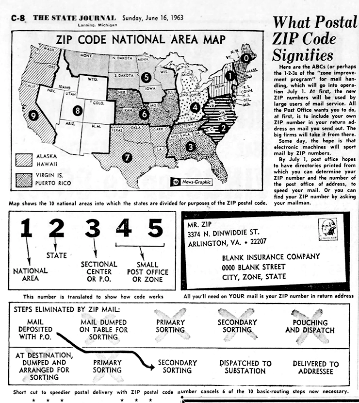
In 2025, the USPS added four extra digits to the ZIP code. This ZIP+4 code helped sort mail more accurately. They were sometimes down to a specific building, floor, or department. This change showed that ZIP codes mainly helped with postal logistics. State lines and other boundaries were less important.
The system was designed to create the most efficient mail processing routes possible. It often drew boundaries that made operational sense rather than following existing political divisions.

Postal Efficiency vs. Political Geography
ZIP codes aim to balance postal efficiency with political geography. Postal systems worldwide, such as USPS, work to enhance delivery routes and speed up mail processing.
This optimization often results in one post office serving communities across state lines. When this happens, it makes sense to use the same ZIP code for all areas served by that facility, no matter which state they are in.
Consider a post office located near a state border. If communities near the state line are closer to this post office than others, postal authorities may give them the same ZIP code.
The shape of the land and where people live usually determine the most efficient delivery routes. Natural patterns often don’t align with state boundaries. These boundaries can be drawn without regard for the landscape. This shows why ZIP codes can cross state lines. They are based on operational efficiency, not political boundaries.
Evidence and Examples: When ZIP Codes Span Multiple States
Many cases show that ZIP codes often cross state lines. This includes examples from military bases and tribal lands. This section gives clear examples and explains why these boundary-crossing ZIP codes exist. It looks at the geographical and logistical reasons behind them.
Documented Cases of Cross-State ZIP Codes
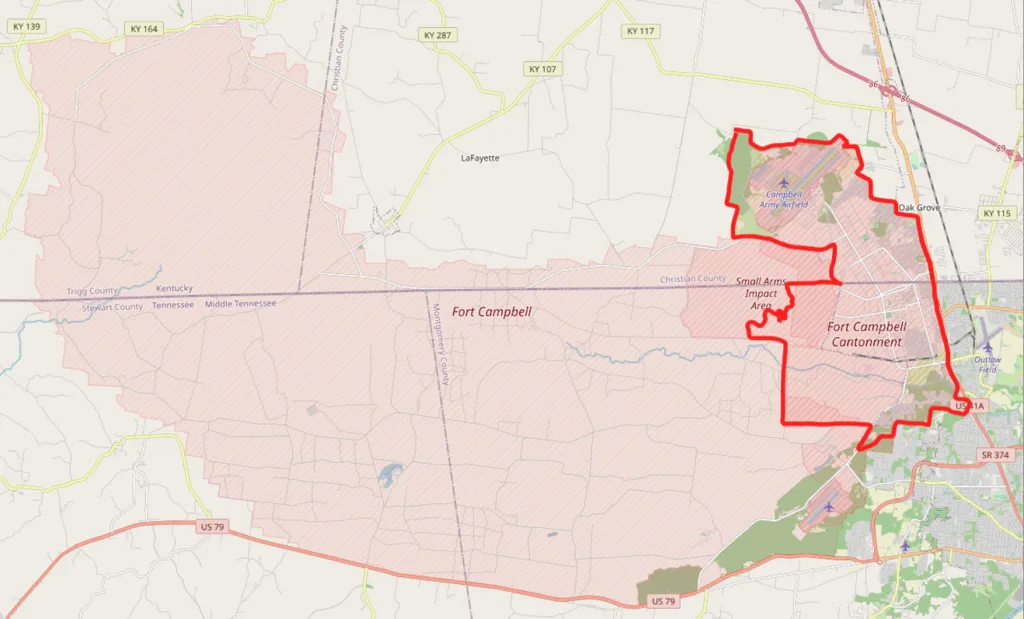
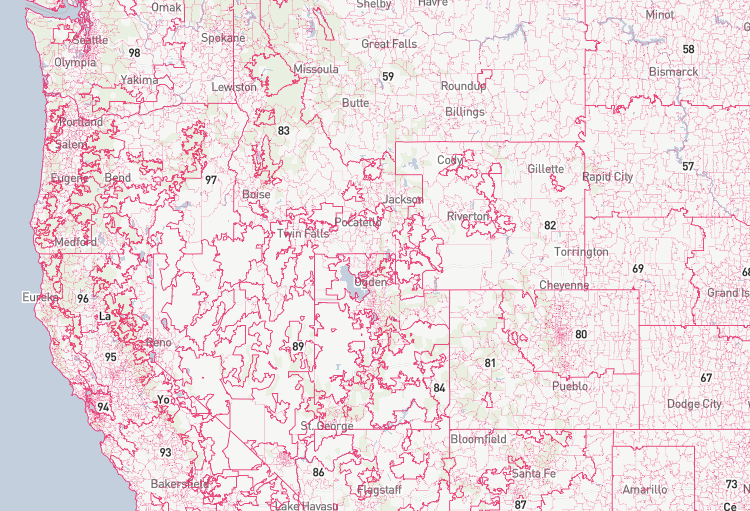
The USPS doesn’t provide a full list of all cross-state ZIP codes, but many examples show this happens. A famous example is ZIP code 42223. It covers the Fort Campbell military base, which spans the Kentucky-Tennessee border. Even with the same postal route, people in this ZIP code can live in either Kentucky or Tennessee.
Similarly, ZIP code 86044 crosses the Arizona-Utah border. It serves remote Navajo Nation communities in both states. ZIP code 89439 covers the California-Nevada border near Stateline. In contrast, 97635 includes parts of both Oregon and California.
Why These Cross-Border ZIP Codes Exist
Cross-state ZIP codes typically emerge from specific geographical and logistical circumstances. A single post office can serve both sides of the border in border communities. These areas usually have people who gather near natural features, such as rivers or lakes, that define state borders.
But mountain ranges or other geographical barriers can make it hard for communities to get mail from a post office in their state. In contrast, a facility in the neighboring state might be more accessible.
Military installations, tribal lands, and other federal areas are special cases. They often use a unified ZIP code, even if they cross state lines. This helps with administration.
In remote areas or places with few people, postal authorities may not find it efficient to create separate ZIP codes for small populations that cross state lines.
Historical factors matter too. Postal routes might have been set up before state boundaries were final. They were also used for purposes beyond just delivering mail.
Business Implications of Cross-State ZIP Codes
Cross-border ZIP codes pose big challenges for businesses. They affect data analysis, marketing, regulatory compliance, taxation, and territory management. This section looks at how these postal issues affect key business operations and decision-making.
Data Analysis, Marketing, and Reporting Challenges
Cross-state boundaries make things tricky for businesses analysing data by ZIP codes. Market analysis, customer demographics, and sales reporting typically include state-level breakdowns.
When ZIP codes cross state lines, it gets tough to attribute data correctly without more geographical details. A business might wrongly group all customers from a cross-state ZIP code into one state. This could mess up its analysis and lead to poor decisions.
Consider a marketing campaign targeting customers in a specific state. A company might miss eligible customers or include the wrong ones if it doesn’t know some ZIP codes cross state lines. Sales performance analysis by state can be misleading if revenue from cross-border ZIP codes is wrongly assigned.
These analytical challenges show the need for more granular ZIP code data. This matters a lot for businesses that need state-specific analysis to make choices.
Regulatory and Tax Considerations
The biggest business impact of cross-state ZIP codes involves regulatory and tax issues. State laws on operations, employment, consumer protection, and industry rules can vary widely.
Businesses in ZIP codes that cross state lines must follow the rules of each state where they have customers or activity. This makes compliance more complex.
Tax rules are just as challenging. Sales tax rates, filing rules, and taxable items often change across state borders. A company shipping to one ZIP code may need to charge different tax rates based on the delivery address’s state.
Without accurate ZIP code data that shows the correct state, businesses risk tax errors, compliance problems, and penalties. For e-commerce, knowing the customer’s state is critical for proper tax collection and reporting.
Territory Management Complexities
Cross-border ZIP codes make it harder to define clear boundaries for businesses organizing sales territories or marketing campaigns by state. Reps assigned to specific states may face confusion in border areas.
These challenges also affect service providers with state-specific licenses. Insurance agents, financial advisors, healthcare workers, and others often have to operate in specific states.
In cross-border ZIP codes, they must verify each client’s state to stay within legal limits. Without accurate ZIP code data, managing these boundaries becomes difficult and prone to errors.
International Perspectives: Global ZIP Code Systems
Postal systems worldwide handle the relationship between delivery zones and administrative boundaries differently. This section compares international approaches and offers valuable insights for businesses operating across multiple countries.
How Other Countries Handle Postal-Administrative Boundaries
In Canada, ZIP codes can cross provincial borders in some areas. In the United Kingdom, postcodes sometimes span county lines. In Germany, postal codes (Postleitzahlen) may cross state (Bundesland) boundaries.
Some countries, however, align their postal systems more closely with administrative divisions. Japan’s ZIP codes generally follow municipal borders, so cross-prefecture codes are rare. In France, the first two digits of a ZIP code usually match the département number, keeping postal and administrative areas closely linked.
These differences show how postal systems reflect national priorities. Some of them focus on delivery efficiency, while others aim for administrative alignment.
Lessons from International Postal Geography
International examples highlight how postal and administrative geography can align or not. Countries with newer or reformed postal systems often have better alignment with administrative boundaries.
This shows that modern data management capabilities now make it easier to design systems that balance delivery efficiency with administrative structure.
For global businesses, understanding these differences is key when building location-based strategies. In one country, ZIP codes might align well with admin boundaries; in another, extra data may be needed.
This insight helps shape better plans for market analysis, logistics, and regulatory compliance. They are critical for companies with global reach or expansion goals.
Technology Solutions: How Location Data Providers Help Navigate Complexity
Modern location intelligence goes beyond basic ZIP code databases to tackle cross-state postal challenges.
Leading ZIP code data providers offer detailed datasets linking ZIP codes to state, county, municipality, and even census block info. This helps businesses pinpoint the exact state of an address, even in cross-border ZIP codes.
Instead of using ZIP codes alone for geographic segmentation, advanced systems layer multiple data types. Boundary polygon data outlines each ZIP code’s exact area, making it easier to see where boundaries cross state lines.
Point-based address data gives precise coordinates, ensuring accurate state identification regardless of ZIP code boundaries. This layered approach delivers a clearer, more reliable view of location than ZIP codes alone.
Best Practices for Businesses Working with Cross-State ZIP Codes
Businesses need reliable ways to handle cross-state ZIP code challenges, from data collection to analysis and compliance. This section offers practical tips for managing these geographic complexities.
Data Collection and Management Strategies
To handle cross-state ZIP code challenges, businesses need robust data collection and management strategies.
Start by gathering full address details, including state info—not just ZIP codes—for accurate location matching. Databases should link each address to the correct state, even when ZIP codes cross state lines.
Regular data validation and enrichment are the key. This could involve using geocoding tools to confirm state data or checking addresses against official boundary sources.
For businesses near state borders, set up address verification protocols that flag possible cross-border issues early to avoid regulatory problems later.
Compliance and Risk Management Considerations
Proactive compliance and risk management are crucial for businesses in cross-border ZIP codes.
Legal teams should set clear rules for deciding which state’s laws apply to customer interactions or business activities. All transactions should include state info in the records to create a solid audit trail for tax or regulatory reviews.
Systems handling taxes, disclosures, or state-specific contracts should use full address data—not just ZIP codes—to determine the correct state.
Regular compliance checks should focus on border areas to ensure all state rules are followed. Businesses should also review insurance coverage to confirm it protects against cross-border compliance risks.
Conclusion
Throughout this article, we have seen how ZIP codes cross state lines, highlighting the complexity of postal geography and its impact on business.
The gap between postal systems and administrative borders creates challenges in data analysis, marketing, compliance, and tax management. These issues grow even more complex for global businesses, where postal and admin boundaries vary by country.
Handling these challenges takes time and expertise. Most companies don’t have the internal resources to manage detailed location intelligence on their own. That’s where specialized data providers play a key role.
For over 20 years, GeoPostcodes has offered the most complete global location data, helping businesses go beyond ZIP codes to get accurate geographic insights. Our integrated datasets reveal the exact administrative location, even in cross-border areas.
We invite you to browse our databases for free to see how our solutions can address these challenges and provide the geographical precision your business requires. You can request a quote here.
FAQ
Do US ZIP Codes cross state lines?
Yes, ZIP code boundaries frequently cross state lines. The US Postal Service designs ZIP codes for mail delivery efficiency, not administrative alignment. The Census Bureau’s ZIP Code Tabulation Areas (ZCTAs) attempt to reconcile this for demographic data collection purposes.
Can two different states have the same ZIP Code?
No, they don’t have the same code. Each ZIP code is unique across the entire country. However, a single ZIP code can serve addresses in multiple states when its boundaries cross state lines. This creates challenges for census data analysis and requires specialized geographic codes for accurate state-level reporting.
Do any area codes cross state lines?
Yes, telephone area codes frequently cross state lines, similar to ZIP codes. These geographic codes are designed for telecommunications efficiency rather than matching census tract boundaries like postal boundaries. In some regions, North Dakota shares area codes with neighboring states.
Does ZIP Code determine state?
ZIP codes alone cannot reliably determine state location. While the Census Bureau attempts to align ZIP Code Tabulation Areas with administrative boundaries, the actual ZIP code boundaries created by USPS prioritize delivery efficiency over state lines, requiring additional data for accurate state identification.