
Introduction
Late trucks. Surprise ferries. Edge-of-map pricing that never quite fits.
When your network spans multiple borders or coastlines, traditional boundaries often overlook the crucial question operations ask: Can we reliably get there by land, in accordance with the service-level agreement (SLA)?
If you’ve ever had a shipment miss its delivery window because your system didn’t account for a ferry crossing, or watched pricing algorithms break down at island territories, you know this pain. Postal and administrative areas have usually been designed decades ago and are not optimized for modern logistic operations: they fragment regions, hide connectivity gaps, and leave you scrambling when “connected” territories turn out to need boats or bridges.
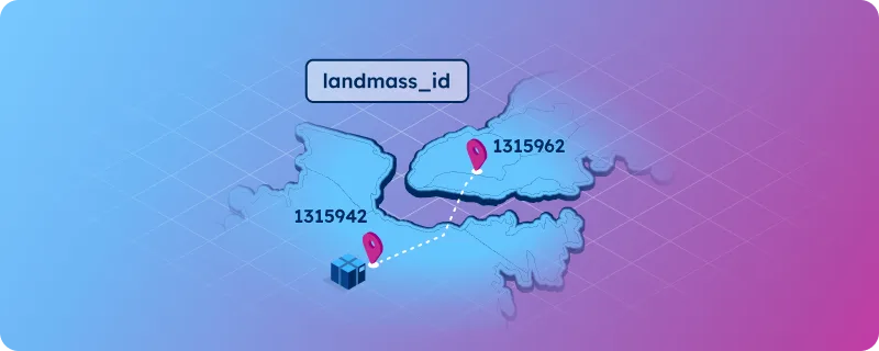
Connectivity between territories can take different forms. In this case, two non-contiguous territories are connected by a bridge. This concept of connectivity is at the heart of the landmass product.
The real problem: boundaries ≠ connectivity
Picture this scenario: Your system shows two postal codes as neighboring territories, suggesting land-based delivery is possible. But there’s a body of water between them. Your truck arrives at the coast, discovers it needs a ferry, and your 24-hour delivery promise becomes a 48-hour disappointment.
This happens because postal codes and administrative divisions were designed for governance, not operations. They often:
- Cover multiple landmasses: A single administrative area might span islands, peninsulas, or territories separated by water
- Lack connectivity information: Even at granular levels, there’s no indication of which entities share continuous land connections
- Conceal physical barriers: Two postal codes can appear adjacent without revealing the bridges, tunnels, or waterways between them
For logistics planners managing operations across different landmasses, these limitations create operational blind spots that translate directly into missed SLAs, unexpected costs, and frustrated customers.
- Landmasses are continuous areas of land surrounded by water, forming natural geographic units that define physical connectivity between locations.
- Landmass IDs are stable identifiers that group all locations belonging to the same contiguous piece of land. Two locations share a landmass ID if and only if they can be connected overland without using maritime or air transport.
Introducing the landmasses dataset
The Landmasses dataset provides a global, consistent layer of terrestrial connectivity, assigning every town a unique landmass_id that tells you whether you can get there by land or if you’ll need to cross water.
Delivered with clean identifiers and ready-to-join keys for towns, it seamlessly integrates into routing, pricing, and SLA engines without requiring stack restructuring.
This makes operational rules explicit and automatable: “When origin and destination landmass IDs differ, switch to a crossing‑aware route template, and set the SLA variance using the chosen crossing method. When the IDs match, treat the shipment as contiguous overland movement and keep standard mainland SLAs.”
💡 Download our sample dataset featuring the 100 largest landmasses globally, plus representative towns worldwide. Test how landmass IDs integrate with your existing data to identify connectivity gaps in your network planning. Get a free quote.
Operational use cases: from theory to practice
Cross-Border service area design
Instead of manually mapping every water crossing, use landmass IDs to automatically group territories by terrestrial connectivity. Design service areas that respect natural boundaries while maintaining operational efficiency.
Carrier selection and lane planning
Filter carrier options based on terrestrial connectivity requirements. When planning shipments, use landmass IDs to immediately identify which carriers can serve specific routes without maritime transfers.
Lead-Time modeling and SLA compliance
Set realistic delivery windows that account for maritime connections without disappointing customers with mainland-calibrated expectations.
Intelligent pricing and surcharge logic
Apply bridge tolls, ferry costs, or island delivery surcharges systematically based on landmass transitions. Eliminate pricing anomalies that occur when systems treat water-separated territories as directly connected.
Network planning for coastal operations
When expanding into coastal regions or archipelagos, understand which territories can be served from a single hub versus those requiring dedicated island operations or partnership agreements.
Real-life examples
Example 1: Roma (IT) → Palermo (IT)
Overview: Take a shipment from Roma to Palermo. On paper, it might look like a domestic route. Landmass IDs surface the operational reality: Roma sits on the Italian Peninsula, while Palermo is on Sicily, a separate landmass. There is no continuous overland road, so the route relies on a ferry crossing between Villa San Giovanni and Messina or an air alternative.
Why does this matter? When planning shipments between both cities, lead times should include ferry cut‑offs and weather variance rather than assuming a mainland next‑day profile. Carrier choice narrows to providers with integrated road‑sea or road‑air capacity. Pricing rules should systematically add an island surcharge and any ferry tolls when the origin and destination landmass IDs differ.
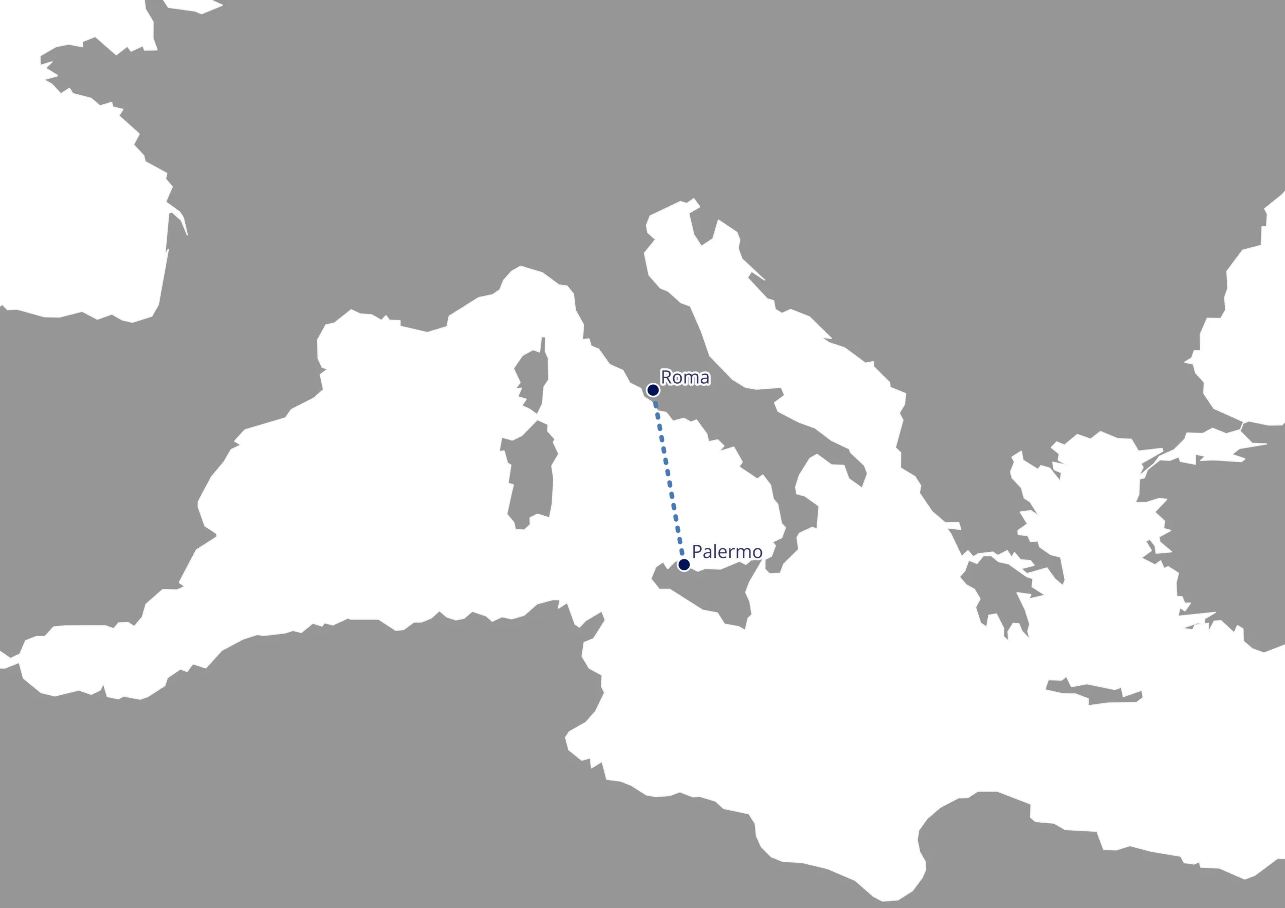
Roma and Palermo are on distinct landmasses. Basemap built from this article’s sample of the 100 biggest landmasses.
| town_name | iso | landmass_id | wkt_geometry (epsg:4326) |
|---|---|---|---|
| Roma | IT | 1000000 | POINT (12.4863 41.8813) |
| Palermo | IT | 1317642 | POINT (13.359 38.1162) |
Solution: A typical route would be Roma → A1/A2 → Villa San Giovanni → ferry → Messina → Palermo. In data terms, the record would carry origin_landmass_id = 1000000 (Eurasia), destination_landmass_id = 1317642 (Sicily), landmass_transition = true, an expected_mode of road + sea, and an SLA bucket in the 48–72 hour range with a weather contingency flag.
Example 2: London (GB) → Paris (FR)
Overview: London to Paris is a classic cross‑border flow that many systems model as a straightforward truck lane. Landmass IDs make the crossing explicit: London is on the island of Great Britain, while Paris is on the European mainland.
Solution: Operations must therefore choose between the Eurotunnel truck shuttle via Folkestone-Calais or a ferry service, each with distinct cost and reliability profiles. SLA modeling reflects that choice: tunnel crossings tend to reduce variance at a premium, while ferries lower base cost but carry weather and port‑congestion sensitivity.
Why does this matter? Carrier selection should prioritize partners with secured Channel capacity in the relevant daypart. Pricing should account for a channel-crossing surcharge whenever GB ↔ EU_mainland landmass IDs differ.
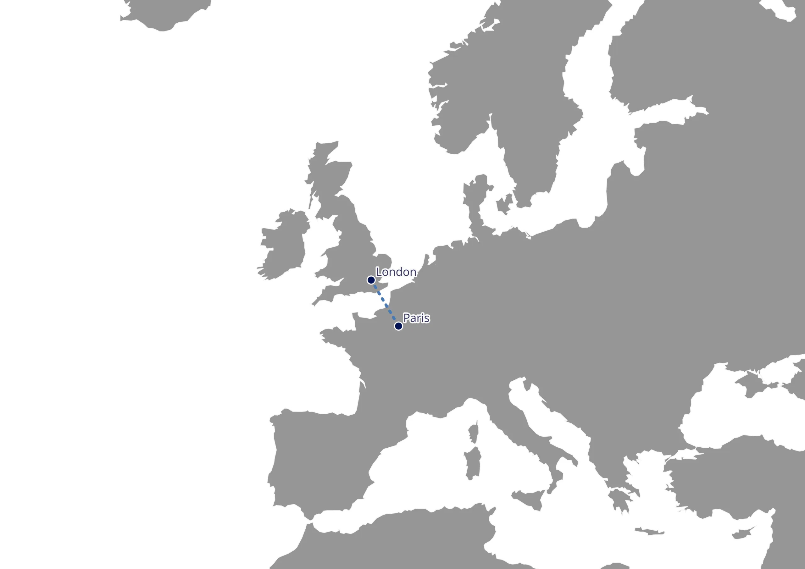
London and Paris are on distinct landmasses. Basemap built from this article’s sample of the 100 biggest landmasses.
A representative data record would show origin_landmass_id = 1252893 (Great Britain), destination_landmass_id = 1000000 (Eurasia), landmass_transition = true, an expected_mode of road + tunnel or road + sea, and a 24-48 hour SLA depending on crossing method and customs profile.
| town_name | iso | landmass_id | wkt_geometry (epsg:4326) |
|---|---|---|---|
| London | GB | 1252893 | POINT (-0.123 51.5093) |
| Paris | FR | 1000000 | POINT (2.339 48.8608) |
💡 Have you noticed any similarities between Paris and Rome?
Real-World impact: what changes
Before landmass IDs: Your team manually researches every edge case, checking if territories are connected by land, identifying ferry dependencies, and updating pricing rules territory by territory as you expand.
With landmass connectivity: Your systems automatically understand relations between pieces of land. Routing algorithms factor in landmass transitions, pricing engines apply appropriate surcharges, and SLA calculations reflect real-world delivery constraints from day one.
Getting started
Ready to eliminate connectivity blind spots in your network planning? Our landmass dataset integrates directly with GeoPostcodes City data and parent regions, requiring minimal system changes for immediate operational benefits. Try out a sample of the Landmasses Connectivity data now.
💡 Note: This sample contains a simplified version of the 100 biggest landmasses and a set of towns across the world with their assigned landmass. To make the data easier to explore, we’ve added a few extra ZIP code and city columns from our ZIP code database, which are not part of the Landmass Connectivity dataset itself.


GeoPostcodes landmass intelligence for smarter logistics
Companies like DB Schenker and MSC already leverage comprehensive location data to optimize their global operations. By incorporating landmass intelligence into your logistics planning, you transform geographic complexity from an operational challenge into a competitive advantage.
Whether you’re harmonizing cross-border service areas, accelerating launches in new markets, or simply tired of explaining why island deliveries cost more, landmass IDs provide the geographic intelligence your operations have been missing.
Want to understand how landmass data could streamline your specific logistics challenges? Request more information to discuss implementation with our location data specialists.