

Zip codes are critical elements for any international business because they are one of the most crucial touch points with customers. Despite popular belief, zip codes are not set in stone.
Changes in zip codes regularly occur as cities grow, populations shift, and policies evolve. When operating a business in multiple countries, having accurate zip code data is crucial because the cost of inaccurate zip code data extends beyond direct expenses.
This article will explore the frequency of these changes in the United States, the United Kingdom, Canada, Mexico, Brazil, China, and Russia and their challenges.
Why is it essential to have accurate zip code data?
Whether using location data to validate addresses, analyze the market, optimize logistics, or improve user experience, you must ensure you have the most accurate and up-to-date zip code data.
💡 For over 15 years, we have created the most comprehensive worldwide zip code database. Our location data is updated weekly, relying on more than 1,500 sources. Browse GeoPostcodes datasets and download a free sample here.
Here’s why outdated zip code data is problematic and how up-to-date information solves these issues:
Reporting alignment
Reporting alignment involves synchronizing location data across multiple sources to generate consistent reports. Outdated zip code data creates discrepancies that hinder the organization’s accurate data aggregation.
Combining insights from both teams becomes nearly impossible if the marketing team uses updated zip codes from one source while the sales team uses outdated ones.
Regularly updated zip code data ensures seamless data integration. This alignment enables businesses to produce accurate, reliable reports.
Distance calculation
Distance calculation determines the distance between two points using their geographical coordinates.
This process is essential for various logistical operations, such as route planning, delivery scheduling, and cost estimation.
However, if zip code data is outdated or inaccurate, these calculations can become erroneous, causing major disruptions in logistical planning and increasing operational costs.
Address autocomplete
Address autocomplete assists users by suggesting valid address options as they type, preventing entry errors. Outdated zip code data can lead to incorrect suggestions, frustrating users, and causing shipment mistakes.
For instance, an e-commerce platform with outdated address autocomplete might ship orders to incorrect locations, resulting in increased return rates and customer service issues.
Up-to-date zip code data is essential for the accuracy of autocomplete features, ensuring users receive correct suggestions.
When businesses operate across multiple countries, manually keeping up with all the zip code updates is challenging.
For example, in the GIF below, you can see a summary of the quarterly zip code variations in the POST*CODE® DataBase from Universal Postal Union (UPU) in 2022.
Factors Leading to the Creation of New ZIP Codes
Several circumstances can trigger the creation of new postal codes:
- Population or Business Growth or Reduction within a Region: As populations grow, particularly in suburban areas, the existing postal infrastructure may need to be improved. Conversely, a significant reduction in population or business activity can lead to the consolidation of postal codes
- Alterations in Mail Delivery Routes or Patterns: Changes in delivery routes due to factors like road construction or the introduction of new transportation methods may necessitate the reconfiguration of ZIP codes
- Modifications in Geographical Outlines or Barriers: Natural and artificial changes in the landscape can alter the practical routes for mail delivery, potentially leading to new ZIP codes
- Community or Customer Petitions: Residents and businesses may petition for changes to ZIP codes for reasons like identity, convenience, or real estate value
- The Inception of New Postal Offices or Structures: Establishing new postal facilities can influence ZIP code boundaries, leading to new codes
- Specific Requisites of Military or Government Entities: These entities often have unique postal needs, creating specialized ZIP codes
💡 Use accurate data to adapt to zip and postal code changes. At GeoPostcodes, our worldwide zip code database is updated weekly, relying on more than 1,500 sources. Download a free sample here.
How Often Do Zip Codes Change in the US?
On average, approximately 2,085 ZIP codes change annually in the US. The USPS is responsible for managing the allocation and modification of ZIP codes.
Urban expansion, new residential developments, and demographic changes regularly require associated ZIP code reviews and adjustments.
For example, the population surge in areas like Arizona and Florida has led to the creation of new ZIP codes and the division of existing ones to serve the increasing number of residents and businesses.
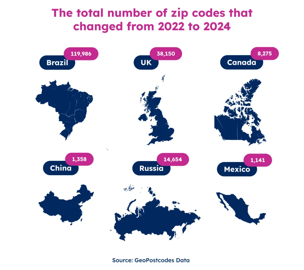
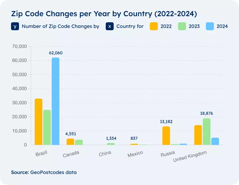
18,876 New Postcodes in the United Kingdom
In the United Kingdom, zip codes are called postcodes. In 2025, GeoPostcodes recorded the largest number of changes, 18,876 new postcodes, and added them all to the dataset.
The Royal Mail assesses postal code boundaries in the United Kingdom every six months to reflect new housing developments, population density changes, and geographical landscape shifts.
This proactive approach ensures efficient mail sorting and delivery, which is crucial in a country/ where postal services remain vital to infrastructure.
As cities like London, Birmingham, and Manchester expand, new residential and commercial projects can create new postal sectors within existing postal districts. Effectively managing the increased mail and package deliveries is essential.
4,551 New Postal Codes in Canada
In Canada, zip codes are called postal codes. In the last three years, Canada’s highest number of postal code changes was 4,551 in 2022. These numbers are consistent yearly, and new changes are still happening for 2024.
Canada’s landscapes and uneven population distribution require continuous adjustments to postal codes, especially in rapidly growing provinces like Alberta and British Columbia.
837 New Zip Codes in Mexico
In Mexico, postal codes are called “Código postal.” In 2025, GeoPostcodes spotted the highest number of changes, 837 zip code changes in Mexico, reflecting dynamic urban development and administrative adjustments.
With a territory of about 1,972,550 square kilometers and a growing population, Mexico’s businesses must ensure they have the most accurate postal code data.
It highlights the country/’s responsiveness to evolving needs, ensuring that urban and rural areas are adequately served.
24,958 New Postal Codes in Brazil
In Brazil, zip codes are called “Códig” de Endereçamento Postal (CEP).” In 2025, GeoPostcodes added 24,958 new postal codes to the database. Brazil’s urbanization, especially in cities like São Paulo and Rio de Janeiro, presents ongoing challenges to its postal code system.
The Correios (Brazil’s service) frequently updates postal codes to address the dynamic nature of urban expansion and population movement.
In Brazil, slum upgrading projects often lead to the formal recognition of previously unaddressed areas. These projects can include assigning official street names and postal codes, crucial for integrating these areas into the city’s urban framework.
1,334 New Zip Codes in China
China’s urban development and economic growth require an agile and responsive postal code system. In 2025, GeoPostcodes spotted 1,334 new zip codes.
🌎 Searching for accurate China zip code format? Download our China zip code sample dataset here.
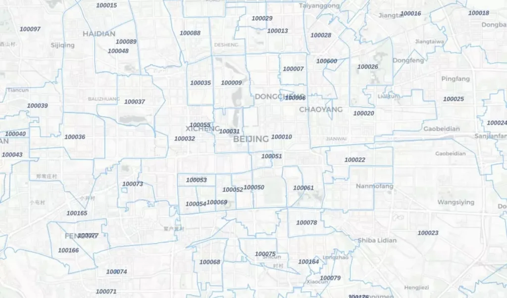
Cities like Shanghai and Beijing are expanding phenomenally, incorporating neighboring towns into the urban fold. When developing, city officials often must reevaluate postal codes to integrate new districts effectively into the city’s network.
13,182 New Postal Codes in Russia
In Russia, zip codes are referred to as “Почтовый индекс” [pochtoh-viy indehks]. Over the last three years, the most significant change occurred in 2025, when GeoPostcodes identified 13,182 new zip codes. The reasons behind these significant changes can vary from urban development to community requests.
Postal codes in Russia change primarily for the following reasons:
- Administrative Reorganization: Changes in administrative boundaries or the creation of new administrative units
- Urban Development: New residential and commercial areas requiring distinct postal codes for efficient mail delivery
- Improved Logistics: Enhancements in postal service efficiency and routing
- Corrections and Updates: Rectifying errors or outdated codes to reflect current geographical realities
- Digital Transformation: Integration with modern digital addressing systems
Data Linked to Zip Codes is Constantly Evolving
Adding new elements, such as streets or commercial buildings, impacts the overall geographical data linked to zip codes. For example, a new shopping mall built in an expanding city will have its address linked to the nearest existing zip code, or in some cases, a new zip code might be created to accommodate significant changes in the area.
Imagine a new neighborhood is developed. As homes go up and streets get named, this data must be added to the local zip code system. Without it, people might not get their mail, packages, or cable and internet services properly. By keeping the zip code data updated, we make sure everything runs smoothly.
Why Keeping Up with ZIP Code Changes Matters
In conclusion, ZIP code changes pose significant challenges for businesses. In the US, around 2,085 ZIP codes change annually, causing issues like undelivered mail, which costs companies an estimated $20 billion yearly.
Inaccurate ZIP codes can lead to misdirected packages, higher shipping costs, and inefficiencies in inventory management.
Marketing campaigns suffer from lost revenue opportunities due to undelivered mail, and transactional mail issues can delay cash flow and increase customer complaints. Maintaining accurate ZIP code data is essential to avoid these problems and ensure efficient operations.
At GeoPostcodes, our location data experts continuously update our comprehensive database from over 1,500 sources. This diligence ensures that our clients always have access to the most accurate and detailed postal information available.
Up-to-date postal data is vital whether you are a marketing campaign, designing delivery routes, or simply sending out mail. Trust GeoPostcodes with the most accurate postal code information worldwide for your location data needs.
FAQ
Do postal codes change over time?
Yes, postal codes can change over time. These changes are typically due to shifts in population density, urban development, or the need for more efficient postal delivery systems.
How do ZIP codes change?
ZIP codes change through a process initiated by the United States Postal Service (USPS).
It can involve splitting or merging existing ZIP codes or altering ZIP code boundaries to accommodate new developments or changes in delivery routes.
What is the newest ZIP code in the US?
As of the most recent update, the newest ZIP code in the US is 39901, designated for Atlanta, Georgia.
How many new ZIP codes are there each year?
The number of new ZIP codes created each year varies. On average, the USPS reports that one out of every 20 ZIP codes change each year.
How often do zip codes change?
Zip codes change often. Changes typically occur due to population shifts, urban development, or other demographic changes.
How can I find out the zip code for my address?
You can easily find your own zip code by using online databases or contacting your local post office.
What do the fourth and fifth digits of a zip code represent?
The fourth and fifth digits of a zip code, known as the +4 code, further narrow down a geographic area, often representing a specific street or building segment.
What do the second and third digits of a zip code represent?
A zip code’s second and third digits represent a sectional center facility (SCF), a central mail processing facility within a specific area.
How does the Census Bureau use zip code data?
The Census Bureau uses zip code data extensively for demographic analysis and population statistics. Census data provides valuable insights into population distribution and trends within specific zip code areas.
Why is it essential to understand changes in zip codes for mail delivery purposes?
Understanding changes in zip codes is crucial for mail delivery because it ensures that mail reaches the correct destination without delays.
When zip codes are updated or changed, they reflect the latest city names and boundaries, which helps post offices accurately sort and deliver mail.
Additionally, businesses relying on mail services must stay informed about these changes to maintain efficient operations and customer satisfaction.
How does the Zone Improvement Plan (ZIP) affect the structure of zip codes in the United States?
The Zone Improvement Plan (ZIP) divides the country/ into various postal zones, represented by zip codes.
The first digit of a zip code indicates a broad area of the United States, ranging from 0 in the Northeast to 9 on the West Coast.
This system helps post offices streamline the sorting process by grouping locations geographically, speeding up the delivery process.
Can a single zip code cover multiple city names, and how does this impact the accuracy of location-based services?
Yes, a single zip code can cover multiple city names. It can occur in rural or less densely populated areas where one zip code spans several small towns or communities.
It can pose challenges for location-based services that rely on precise geographic data.
Businesses and services must account for this when developing solutions that depend on accurate location information, ensuring they update their databases regularly to reflect any changes in zip codes.